| Version | Date | Comments |
|---|---|---|
| v202 | 01.10.2019 | Update to version 202 |
| v201 | 10.01.2019 | Official ESA release |
Main Improvements and Changes in v202
The time coverage resolution has been changed from 7 days to 1 day, meaning that the weekly averaged product is updated every day from now on.
We adapted the CS2SMOS processing to changes due to the update to CryoSat-2 sea ice thickness product version v2.2. Now the CryoSat-2 product can be used for Baffin Bay and Hudson Bay, since a new snow climatology is applied in the retrieval algorithm.
We adapted the CS2SMOS processing to changes due to the update to SMOS sea ice thickness product version v3.2, which is now processed and provided by AWI.
An ocean mask is applied to allow for a consistent land/ocean mask throughout the entire data record in order to overcome inconsistencies due to switches of the land masks in the OSI SAF ice concentration products.
Changes in the NetCDF variable names, fulfilling CF 1.6 conventions.
We now use different sea ice concentration products for the operational mode and for the reprocessing mode. In the operational mode, we use the operational OSI-401 ice concentration product, while in the reprocessing mode, the reprocessed OSI -430-b ice concentration product is used. Both are provided by OSI SAF.
Product Description Overview
| Parameter | Sea ice thickness |
Spatial covergae | N: 90°, S:16.6°, E:180°, W:-180° |
Spatial Resolution | 25 km x 25 km |
Temporal coverage of the data record: | November 2010 to present |
Time coverage resolution | 1 day |
| Time coverage duration | 7 days |
Data Format(s) | NetCDF |
Platforms | CryoSat-2, SMOS |
Version | v202 |
File naming convention
NetCDF files are named using the following convention:
<convention-prefix>_<regional code>- <institution>,<platform(s)>,<grid>_<time>_<mode>_<product version>_<file version>.nc
convention-prefix | World Meteorological Organization: W |
regional code | European: XX |
| institution | European Space Agency: ESA |
processing level/parameter | level 4 sea ice thickness: l4sit |
Platform(s) | satellites: SMOS, CS2 |
grid | 25 km EASE2 grid, Northern Hemisphere: NH_25KM_EASE2 |
time | time span: yyyymmdd - yyyymmdd |
| mode | reprocessing: r, operational: o |
product version | version 2.0.2: v202 |
file version | version 1: 01 |
Example NetCDF naming for operationally processed data:
W_XX-ESA,SMOS_CS2,NH_25KM_EASE2_20190304_20190310_o_v202_01_l4sit.ncExample NetCDF naming for reprocessed data:
W_XX-ESA,SMOS_CS2,NH_25KM_EASE2_20190304_20190310_r_v202_01_l4sit.ncFile Format
The weekly grids are given in standardized binary data format (Network common data form: NetCDF v4). Global attributes are given in Table 1. The variables are given as grid arrays, see Table 2. NetCDF files are formatted according to CF conventions: CF-1.6 ACDD-1.3. We use a scaling factor of 10^-3 and a fillvalue = -2147483647.
Table 1: Global attributes from an example NetCDF file, covering the week from March 04 to March 10, 2019.
Attribute | Value |
|---|---|
| title | Sea Ice Thickness derived from merging CryoSat-2 and SMOS ice thickness |
| description | Weekly Arctic sea-ice thickness derived from CryoSat-2 and SMOS using an optimal interpolation scheme |
| summary | Weekly Arctic sea-ice thickness derived from CryoSat-2 and SMOS using an optimal interpolation scheme |
| keywords | Cryosphere > Sea Ice > Sea Ice Thickness |
| product_version | 202 |
| processing_mode | r |
| time_of_creation | Fri Oct 11 09:04:06 2019 |
| history | Fri Oct 11 09:04:06 2019 creation |
| Conventions | CF-1.6 |
| spatial_resolution | 25.0 km grid spacing |
| geospatial_lat_min | 16.623929977416992 |
| geospatial_lat_max | 90.0 |
| geospatial_lon_min | -180.0 |
| geospatial_lon_max | 180.0 |
| geospatial_vertical_min | 0.0 |
| geospatial_vertical_max | 0.0 |
| time_coverage_start | 2019-03-04T00:00:00Z |
| time_coverage_end | 2019-03-11T00:00:00Z |
| time_coverage_duration | P7D |
| time_coverage_resolution | P1D |
| platform | CryoSat-2, SMOS |
| project | CS2SMOS PDS: SMOS & CryoSat-2 Sea Ice Data Product Processing and Dissemination Service |
| institution | Alfred-Wegener-Institut Helmholtz Zentrum für Polar und Meeresforschung (AWI), http://www.awi.de |
| creator_name | Alfred-Wegener-Institut Helmholtz Zentrum für Polar und Meeresforschung (AWI), http://www.awi.de |
| creator_type | institution |
| creator_url | |
| publisher_email | |
| references | Ricker, R., Hendricks, S., Kaleschke, L., Tian-Kunze, X., King, J., and Haas, C.: A weekly Arctic sea-ice thickness data record from merged CryoSat-2 and SMOS satellite data, The Cryosphere, 11, 1607-1623, https://doi.org/10.5194/tc-11-1607-2017, 2017. |
| _CoordSysBuilder | ucar.nc2.dataset.conv.CF1Convention |
Table 2: NetCDF file content. Note, that we use a scaling factor of 10^-3 and a fillvalue = -2147483647.
Variable | Description | Unit | Type | Dimension |
|---|---|---|---|---|
| Lambert_Azimuthal_Grid | proj4_string: +proj=laea +lon_0=0 +datum=WGS84 +ellps=WGS84 +lat_0=90.0 | - | int | - |
| time_bnds | start and end time of the weekly retrieval | seconds since 1978-01-01 00:00:00 | double | 2 |
| analysis_sea_ice_thickness | CS2SMOS weekly merged sea ice thickness | m | int | 1,432,432 |
| background_sea_ice_thickness | background field, interpolation using CS2 and SMOS sea ice thickness data | m | int | 1,432,432 |
| weighted_mean_sea_ice_thickness | weighted mean of weekly CS2 and SMOS ice thickness retrievals | m | int | 1,432,432 |
| innovation | difference between background and analysis ice thickness | m | int | 1,432,432 |
| sea_ice_concentration | sea ice concentration | % | int | 1,432,432 |
| sea_ice_type | sea ice type | - | int | 1,432,432 |
| correlation_length_scale | correlation length scale of background ice thickness | m | int | 1,432,432 |
| analysis_sea_ice_thickness_unc | uncertainty of the merged sea ice thickness | m | int | 1,432,432 |
| smos_sea_ice_thickness | weekly averaged SMOS ice thickness | m | int | 1,432,432 |
| cryosat_sea_ice_thickness | weekly averaged CryoSat-2 ice thickness | m | int | 1,432,432 |
| time | reference time of product (middle of the week) | seconds since 1978-01-01 00:00:00 | double | 1 |
xc | x coordinate of projection (eastings) | km | float | 432 |
yc | y coordinate of projection (northings) | km | float | 432 |
lon | longitude coordinate | degrees_north | float | 432,432 |
lat | latitude coordinate | degrees_east | float | 432,432 |
Grid
All grids are projected onto the 25 km EASE2 Grid, which is based on a polar aspect spherical Lambert azimuthal equal-area projection (Brodzik et al., 2012). The grid dimension is 5400 km x 5400 km, equal to a 432 x 432 grid. The grid is centered on the geographic Pole, meaning that the Pole is located at the intersection of center cells (Figure 1).
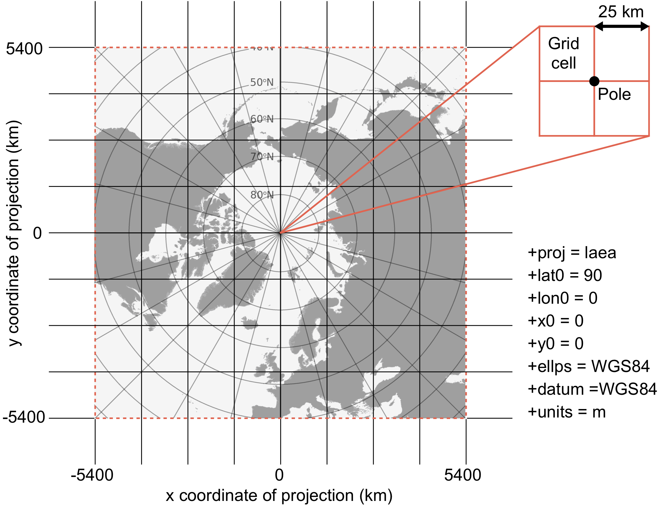
Figure1: Specifications of the EASE2 25 km grid, which is used for the merged product.
Links
ESA Websites:
Visualization of NetCDF data: