...
...
...
...
...
...
...
...
...
...
...
<institution>-<product>-<processing level>-<parameter>-<platform(s)>-<mode>-<grid>-<time>-<version>.nc
...
institution
...
Alfred Wegener Institute (AWI): awi
...
product
...
CryoSat-2/SMOS merged product: cs2smos
...
processing level
...
Level 4: l4
...
parameter
...
Sea ice thickness: sithick
...
Platform(s)
...
Satellites: SMOS, CryoSat-2
...
mode
...
Reprocessing: rep, near-real-time: nrt
...
grid
...
25 km EASE2 grid, Northern Hemisphere: nh25km_ease2
...
time
...
Time span: yyyymmdd - yyyymmdd
...
version
...
Version 2.0: fv2p0
Example NetCDF naming for near-real time processed data:
awi-cs2smos-l4-sithick-cryosat2_smos_merged-nrt-nh25km_ease2-20180326_20180401-fv2p0.ncExample NetCDF naming for reprocessed data:
...
...
...
...
...
...
Sea Ice Thickness derived from merging CryoSat-2 and SMOS ice thickness
...
description...
Weekly Arctic sea-ice thickness derived from CryoSat-2 and SMOS using an optimal interpolation scheme
...
summary...
Weekly Arctic sea-ice thickness derived from CryoSat-2 and SMOS using an optimal interpolation scheme
...
keywords...
Cryosphere > Sea Ice > Sea Ice Thickness
...
product_version...
fv2p0
...
processing_mode...
rep
...
time_of_creation...
Mon Oct 22 17:27:55 2018
...
history...
Mon Oct 22 17:27:55 2018 creation
...
Conventions...
CF-1.6 ACDD-1.3
...
spatial_resolution...
25.0 km grid spacing
...
geospatial_lat_min...
...
...
...
...
...
...
2018-03-26T00:00:00Z
...
time_coverage_end...
2018-04-01T00:00:00Z
...
time_coverage_duration...
P7D
...
time_coverage_resolution...
P7D
...
platform...
CryoSat-2, SMOS
...
project...
CS2SMOS PDS: SMOS & CryoSat-2 Sea Ice Data Product Processing and Dissemination Service
...
institution...
Alfred-Wegener-Institut Helmholtz Zentrum für Polar und Meeresforschung (AWI), http://www.awi.de
...
creator_name...
Alfred-Wegener-Institut Helmholtz Zentrum für Polar und Meeresforschung (AWI), http://www.awi.de
...
creator_type...
institution
...
creator_url...
https://spaces.awi.de/confluence/x/DwVmEQ
...
publisher_email...
...
references...
...
...
...
...
...
...
...
...
...
...
...
...
...
...
ucar.nc2.dataset.conv.CF1Convention
...
...
Lambert_Azimuthal_Grid...
Add description
...
-
...
int
...
-
...
time_bnds...
Start and end time of the weekly retrieval
...
seconds since 1978-01-01 00:00:00
...
int
...
2
...
analysis_ice_thickness...
CS2SMOS weekly merged sea ice thickness
...
m
...
Int
...
1,432,432
...
background_ice_thickness...
background field, interpolation using CS2 and SMOS sea ice thickness data
...
m
...
Int
...
1,432,432
...
weighted_mean_ice_thickness...
weighted mean of weekly CS2 and SMOS ice thickness retrievals
...
m
...
Int
...
1,432,432
...
innovation...
difference between background and analysis ice thickness
...
m
...
Int
...
1,432,432
...
ice_conc...
sea ice concentration
...
%
...
Int
...
1,432,432
...
ice_type...
sea ice type (OSI-403-c)
...
-
...
Int
...
1,432,432
...
correlation_length_scale...
correlation length scale of background ice thickness
...
m
...
Int
...
1,432,432
...
analysis_thickness_unc...
uncertainty of the merged sea ice thickness
...
m
...
Int
...
1,432,432
...
smos_ice_thickness...
weekly averaged SMOS ice thickness
...
m
...
Int
...
1,432,432
...
cs2_ice_thickness...
weekly averaged CryoSat-2 ice thickness
...
m
...
Int
...
1,432,432
...
time...
reference time of product (middle of the week)
...
...
...
xc
...
x coordinate of projection (eastings)
...
km
...
Int
...
432
...
yc
...
y coordinate of projection (northings)
...
km
...
Int
...
432
...
lon
...
longitude coordinate
degrees_north
...
Int
...
432,432
...
lat
...
latitude coordinate
degrees_east
...
int
...
Grid
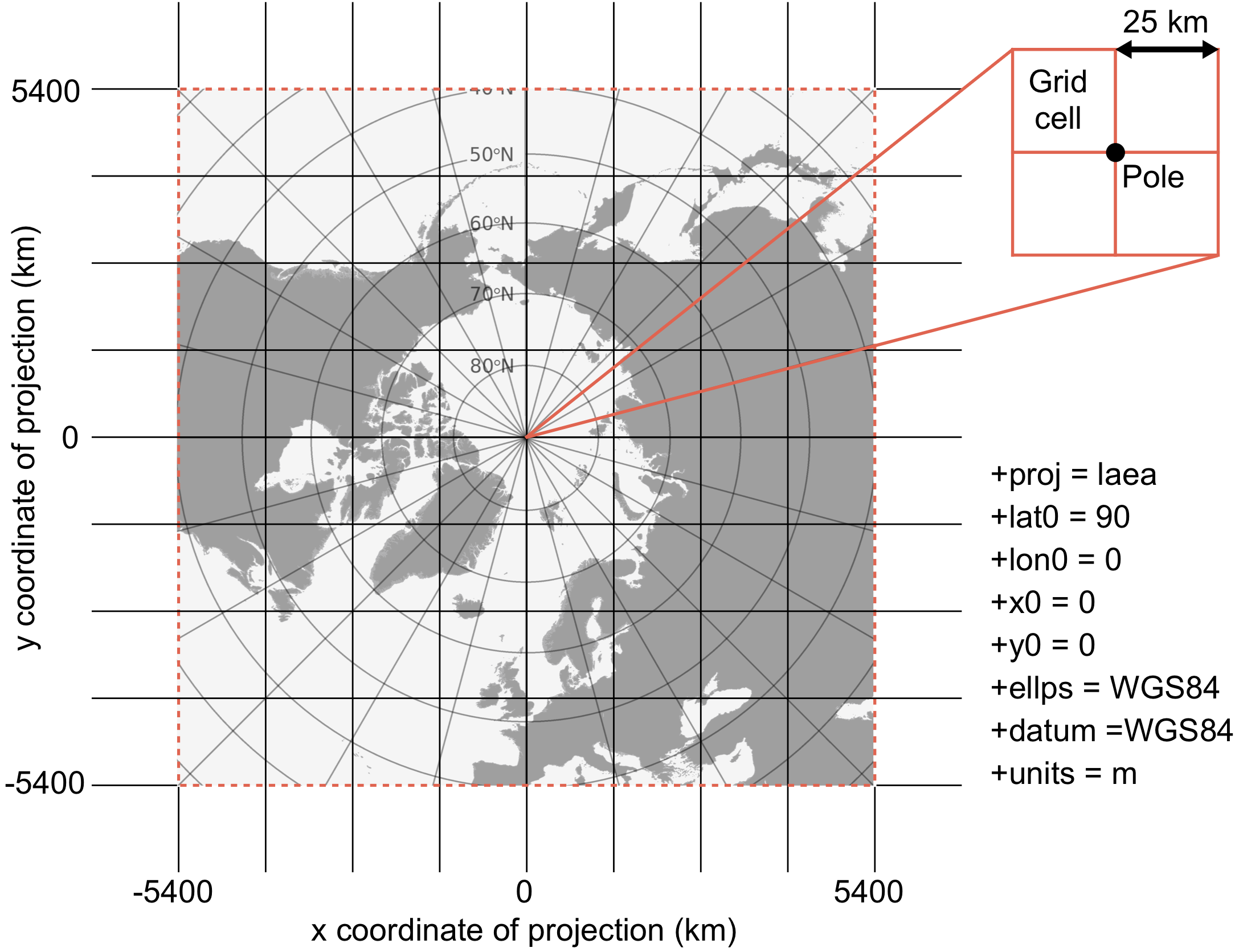
All grids are projected onto the 25 km EASE2 Grid, which is based on a polar aspect spherical Lambert azimuthal equal-area projection (Brodzik et al., 2012). The grid dimension is 5400 km x 5400 km, equal to a 432 x 432 grid. The grid is centered on the geographic Pole, meaning that the Pole is located at the intersection of center cells (Figure 1).
LinksESA Websites: |
| Panel | ||||||||
|---|---|---|---|---|---|---|---|---|
| ||||||||
Contact |
...