Summary
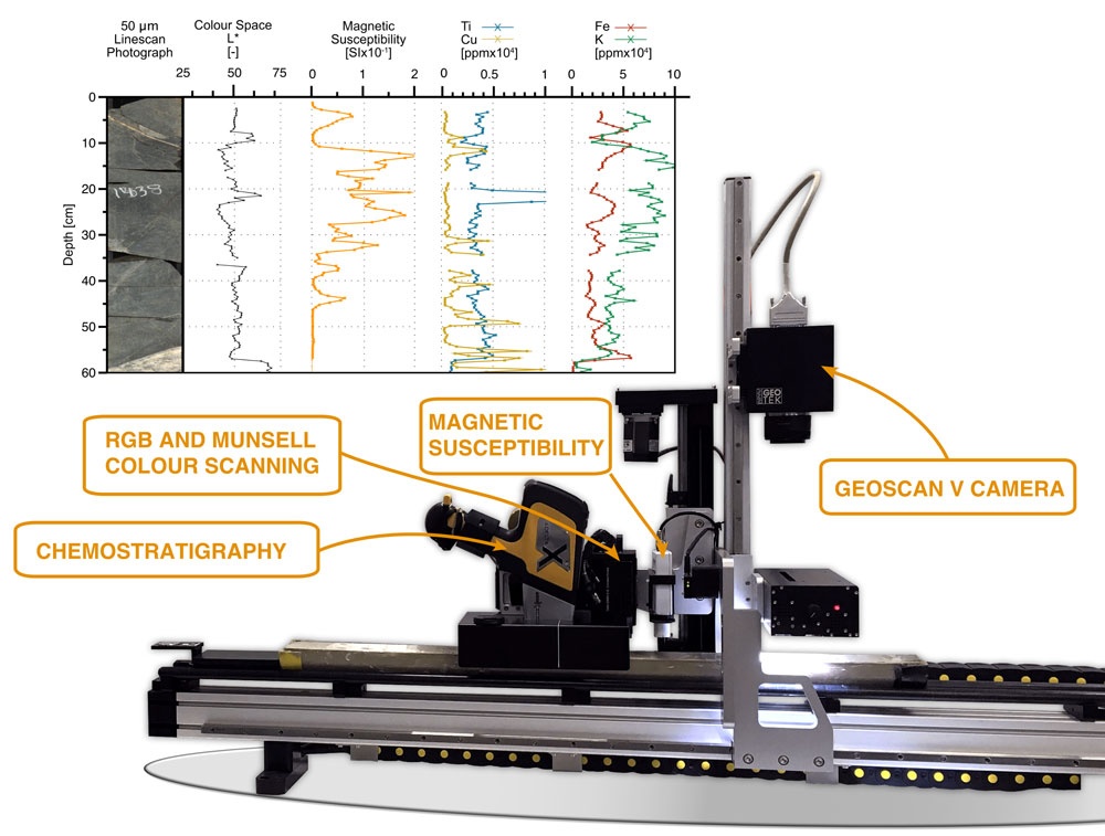
The MSCL-XZ is a benchtop or small-footprint core logging system that provides a compact solution for split core non-destructive measurements, obtaining multiple data sets simultaneously. Unlike the MSCL-S, where the core moves past the sensors, the bench-top MSCL-XZ moves the sensors along the core (X-axis) while the sensors move up and down to contact the core surface (Z-axis). Split core sections enable sensors to be used that cannot operate through the plastic liner: X-ray fluorescence (Olympus Delta handhold), colour spectrophotometry, high-resolution magnetic susceptibility, and Geoscan V linescan core imaging.
Manufacturer: Geotek Ltd.
Model: MSCL-XZ
Serial No: 116
Type: Multi-Sensor Benchtop Logger
| Role | Name |
|---|
| Principal Investigator | Frank Niessen |
| Data Scientist | Catalina Gebhardt |
| Engineer in Charge | Dietmar Penshorn |
Components
Benchtop or small-footprint core logging system with following sensors: X-ray fluorescence, colour spectrophotometer, high-resolution magnetic point susceptibility, Geoscan V linescan core imaging. Fully automated motion in the horizontal and vertical axes. Linear precision: 0.02 mm. All sensors are moved in unison and collect data in parallel. Data acquisition unit and electronics.
Sensor Type |
Olympus Delta handheld X-ray fluorescence (XRF) |
Minolta Colour Spectrophotometer |
Magnetic Susceptibility Bartington MS2E "point" sensor |
Geoscan V Linescan Imaging |
Manufacturer |
Olympus |
Minolta |
Bartington |
Geotek Ltd. |
Components |
Olympus Delta handheld X-ray fluorescence (XRF)
mounting
counterbalance weight |
Minolta colour spectrophotometer (39 spectral bands) |
Magnetic Susceptibility Bartington MS2E "point" sensor |
Geoscan V Linescan Imaging Camera specifications:
Pixel Sensors: 1x 5K CGD
Visible or Ultraviolet light source
ADC resolution: 14 bits per colour channel
correlated double sampling with exposure control
max pixel rate: 3.2M pixels/sec
max scan rate: 200 lines/sec
down core resolution: upt ot 10 microns
camera control: auto focus, aperture and lighting
data transmission: gigabyte ethernet interface
Canon lens mount |
Position
No fix onboard location.
Data logging, storage and archiving
Logged parameters
X-ray fluorescence (XRF), Colour Spectrophotometry, high-resolution magnetic point susceptibility, Linescan Core Imaging
Central geographical ship's position and time standard
No time synchronising.
No online ship's position.
Rawdata storage on board
Local storage on MSCL-XZ electronic. Operator is in charge of data backup.
Dship
No data transfer to DShip.
Data archiving on land
Not implemented, responsibility with respective user.
Documentation
http://www.geotek.co.uk/products/mscl-xz/
https://www.olympus-ims.com/en/xrf-xrd/delta-handheld/delta-prof/
http://www.geotek.co.uk/products/spectrophotometer/
http://www.geotek.co.uk/products/magsusc/
http://www.geotek.co.uk/products/geoscan/