| Note | ||
|---|---|---|
| ||
The need of the system has to be announced in cruise planning document "Einsatzplanung" prior to the cruise. The mounting of USBL antenna is executed by ships crew, the operation of the system must be executed by experienced scientific staff. Mounting of antenna takes ca. 45 minutes: removing ice protection of moon pool and lowering GAPS is operated by ship's command only. |
Summary
Responsible Persons
Components
| Metadata (Metadata Plugin) | ||
|---|---|---|
| ||
??? |
Position
Data logging, storage and archiving
Logged parameters
Central geographical ship's position and time standard
| Metadata (Metadata Plugin) | ||
|---|---|---|
| ||
??? Time synchronising ??? |
| Metadata (Metadata Plugin) | ||
|---|---|---|
| ||
??? geographical ship's position ??? |
Rawdata storage on board
| Metadata (Metadata Plugin) | ||
|---|---|---|
| ||
Data storage in DShip system.
|
Dship
| Metadata (Metadata Plugin) | ||
|---|---|---|
| ||
Uncorrected measurement data |
| Metadata list |
|---|
|| Device name | GAPS ||
|| Parameters | day; depth \[m\]; EW; latitude \[°\]; longitude \[°\]; month; NS; time in hours; transponder no sag; transponder no sax; x coordinate \[m\]; y coordinate \[m\]; year; z coordinare \[m\]; pitch \[deg\]; roll \[deg\]; heading std dev \[deg\]; pitch std dev \[deg\]; roll std dev \[deg\]; altitude std dev; latitude std dev; longitude std dev; heading \[deg\] || |
Data archiving on land
| Space Metadata (Metadata Plugin) | ||
|---|---|---|
| ||
After the cruise the DShip data set can be extracted from https://dms.awi.de.
??? https://www.pangaea.de/ (for authorized users only) ??? |
| Metadata list |
|---|
|| File format(s) | ??? ||
|| Calibration certificates | ??? || |
Documentation
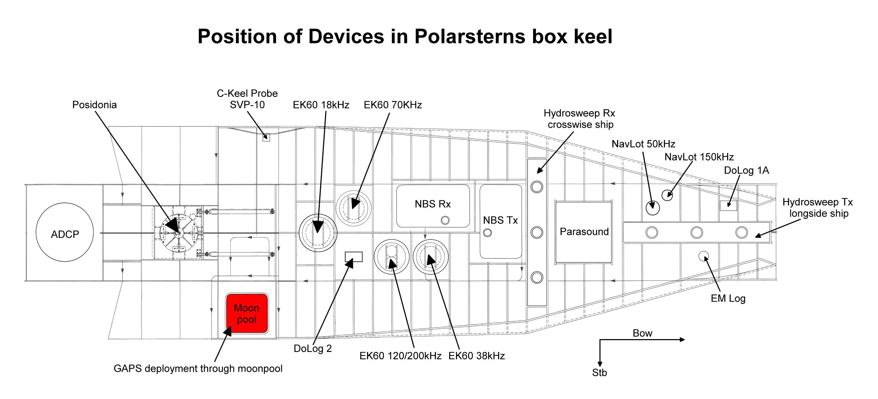
antenna. The reverse procedure for deinstallation takes the same time. In case of sea ice conditions the system must be operated with no ship speed but following ROV or drifting is allowed. In ice free conditions moving of ship is allowed up to 5 knots. Opening angle detecting transponders theoretically amounts to 200 degree. But you need to take the obstruction by means of ships hull into account. In the actual version there is no compatibility to USBL system POSIDONIA (USBL-Box), which is also available on board Polarstern. Online data stream of GAPS is broadcasted via UDP, which can be used by alternative visualization tools (e.g. PosiView) or for seperately logging. GAPS underwater communication is conducted by using various frequencies, interferences with simultaneously operating Echo Sounders are possible. Attention: Submarine cable must be connected and device must be submerged in water through moonpool in box keel before activating GAPS. |
Summary
| Sensorweb integration | ||||
|---|---|---|---|---|
| ||||
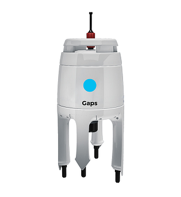
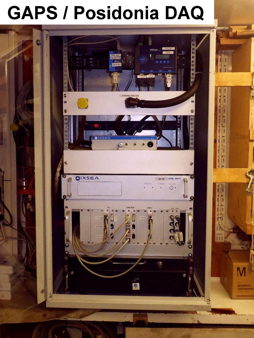
The Global Acoustic Positioning System (GAPS) combines an ultra-short baseline (USBL) acoustic positioning system and an inertial navigation system (INS) in the same housing to provide accurate position of any subsea object supplied with a transponder. Operating range is up to 4000m water depth with accuracy 0.2 percent of the distance to the object. The registration angle of 200 degree also enables position detection nearby sea surface. Electronic device ECB (Easy Connection Box) is installed in echo sounder device room E-525a. Operation is performed by software MMI. |
| Sensorweb integration | ||||||||||
|---|---|---|---|---|---|---|---|---|---|---|
| ||||||||||
|
| Sensorweb integration | ||||
|---|---|---|---|---|
| ||||
   |
Transducer Frequency:
| Metadata (Metadata Plugin) | ||
|---|---|---|
| ||
Contacts
| Sensorweb integration | ||||||
|---|---|---|---|---|---|---|
| ||||||
|
Components
| Metadata (Metadata Plugin) | ||
|---|---|---|
| ||
Position
| Sensorweb integration | ||||||||
|---|---|---|---|---|---|---|---|---|
| ||||||||
|
Data logging, storage and archiving
Logged parameters
| Sensorweb integration | |||||||||||||||||||||||||||||||||||||||||||||
|---|---|---|---|---|---|---|---|---|---|---|---|---|---|---|---|---|---|---|---|---|---|---|---|---|---|---|---|---|---|---|---|---|---|---|---|---|---|---|---|---|---|---|---|---|---|
| |||||||||||||||||||||||||||||||||||||||||||||
|
Central geographical ship's position and time standard
| Metadata (Metadata Plugin) | ||
|---|---|---|
| ||
Rawdata storage on board
| Metadata (Metadata Plugin) | ||
|---|---|---|
| ||
Dship
| Metadata (Metadata Plugin) | ||
|---|---|---|
| ||
| Metadata list |
|---|
Data archiving on land
| Metadata (Metadata Plugin) | ||
|---|---|---|
| ||
| Metadata list |
|---|
Documentation
| Sensorweb integration | ||||
|---|---|---|---|---|
| ||||
...