Page History
...
Either you provide your data (product) directly as an OGC Web Service (OWS) – most probably a Web Mapping Service (WMS) – which can easily be integrated into the Viewer. Or the O2A Spatial Data Infrastructure (SDI) will host an OWS based on your data. For the latter case, the "flow path" through the SOP schema depends on the type of your data, the desired type/structure of OWS and your preferred way of data exchange with the O2A SDI. See the Exchange Protocol section for details.
This document does not provide information on SDI-internal processing/architecture. This is covered here: Technical Infrastructure.
...
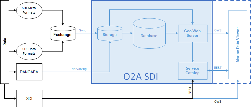
This schema shows possible data flows from your data to the Viewer. It is divided into SDI-external elements (depicted as black elements) and SDI-internal elements (depicted as blue elements). The former describe states/processes you will have to take care of after the Initial Consultation, the latter are designed to work fully automated and will be configured by the administrators (see Contact).
Initial Consultation
Make Contact. Based on a joint assessment of the data situation and the desired outcome we will decide upon an appropriate SOP flow path. The following questions will be discussed.
...
Via O2A Spatial Files
- Supported file types
- data
- vocabulary harmonisation (if applicable)
- Supported exchange location (see Exchange Folder Specification)
- Git repository
- e.g. via Helmholtz GitLab → DataHub
- Isilon project folder
- Git repository
...
Overview
Content Tools