Item types
Generally speaking: everything is an item in registry.awi.de, covering the whole range of platform-like items. Examples of items in sensor.awi.de are not only vessels, AUVs, or measuring stations, but also collecting instruments, such as fish nets, pumps, or grabbing systems, and the sensor itself, such as methane sensor, piezometer, and nutrient analyser.
We always strive to use standardized vocabularies to describe items in registry.awi.de, such as NERC (BODC 2021). Thus, for instance, the item "losgatos_awi_1303" can be attributed to one of the cavity enhanced absorption spectrometers operated at AWI (http://vocab.nerc.ac.uk/collection/L05/current/LAB38/2/). Nonetheless, items cannot always be attributed with standardized vocables.
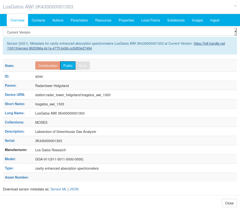
Every item must be assigned to a type (see table below). In the example, the LosGatos AWI 3K430000001303 is of type cavity enhanced absorption spectrometers. Its parent item is the station Radartower Helgoland.
|
|---|
| Overview tab of LosGatos AWI 3K430000001303 (4044) – Labversion of Greenhouse Gas Analyzer – at registry.awi.de. |
Short names and URN syntax
Short names are the semantical foundation of every item. They are required to be as unique as possible, so it has proven to be good practise to attach the serial or asset number to the item, e.g. losgatos_awi_1303.
Even if there are numerous examples, short names shall be lower case only. Technically it is possible to set them upper case, but there are other places in the process chain that are case-sensitive. Be also aware that you cannot create items with the same short name under one parent item.
The respective setup of an item can be derived from the full URN (Uniform Resource Locator). It is the concatenation of all participating items, e.g.:
- station:radar_tower_helgoland:losgatos_awi_1303: the item losgatos_awi_1303 is mounted to the station:radar_tower_helgoland
- vessel:mya_ii:fb_741202:fsi_9999a: the FSI_9999a (type: thermosalinograph) is attached to FB_741202, and in return that is mounted to Mya_II
The topmost item in the URN hierarchy is also stated with its item type, such as vessel.
Occasionally items are not assigned to a specific parental item, e.g when drifters are deployed somewhere. Then the URN reads without parental item, e.g. drifter:drifter_gmr_bgcd01 (6070) and it is a free-floating item with a URN syntax derived from the item type.
Recently the development of registry.awi.de brought UUIDs for everything. The item station:radar_tower_helgoland:losgatos_awi_1303 has the UUID af127496-b8a6-4c4d-9b95-8c42f6a22afe. As of today (2021-06-17 15:18:15) UUIDs are only available via API.
Status of an item
Newly created items are assigned the state construction and can be seen and accessed by the owner (you) exclusively. Only items set to public are readable in public. If the item is not operative at the moment send it to devicestore and it is still accessible to others. If there are larger changes to the item and it (might) take a while until it is used again, please set it to construction again.
In the UI only three states are available to the editors. If you want to retire (decom) an item, the API must be utilized.
|
|---|
| Available states in the UI |

Available states via API
| name | id | meta | uuid |
|---|---|---|---|
| public | 1 | Item is completely describe and in use | a080ff68-30b2-450a-9a44-06ecd244c0b7 |
| construction | 2 | Item description is currently being created | 380e59eb-5f70-4d6f-9f79-c212c5141e20 |
| devicestore | 3 | Item is currently not on a mission | d251b7d5-3476-4606-81d4-1f76632eb802 |
| decom | 4 | Item is retired and not used anymore | 8fa8fd50-a2bf-49ea-991d-03b85cee1b7f |
History and Citing
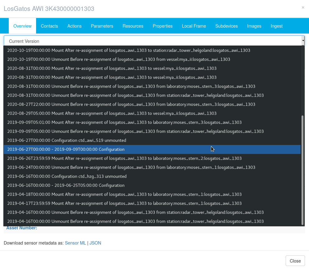
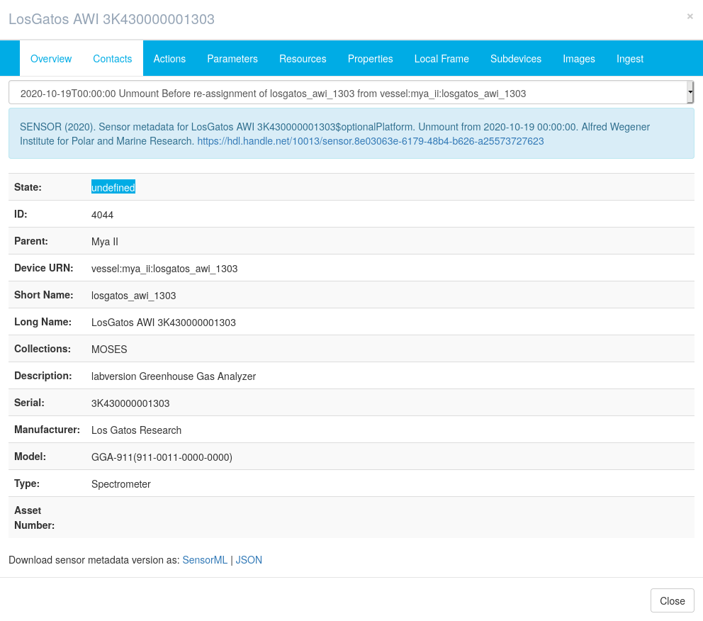
In .awi.de the history per item is tracked. Two entities must be considered: history of item configurations and history of item operations.
In the UI always the most recent configuration of the item is displayed. Former item configurations are accessible via the dropdown menu (below the blue bar on the top). Each item version comes with a PID, such as https://hdl.handle.net/10013/sensor.8e03063e-6179-48b4-b626-a25573727623, thus you can specificly address and reference a certain setup of your device, e.g. in reports or articles. This was used for example by Wulff, Lehmenhecker, and Hagemann (2016) when they referenced https://doi.pangaea.de/10013/sensor.664525cf-45b9-4969-bb88-91a1c5e97a5b to describe configuration of an AUV.
Following the link leads to a former setup of the item. (link: https://hdl.handle.net/10013/sensor.9fd3386a-6c1a-4775-bcbb-cc5d50e27494)
|
|
|
|---|---|---|
Remark: Some actions necessarily create a new version (https://spaces.awi.de/x/0oa0FQ). Versioning is permanently applied to all items and subitems, even if an action is applied to an item but not to its subitems each subitem gets a new handle as well, however, the action itself is not written to the subitems. This behavior is intended to have a proper documentation of the items, even if parts are not involved in certain phases of a measurement procedure.
For item operations the Actions (see https://spaces.awi.de/x/0oa0FQ) are the place to store and handle such things.
References
- British Oceanographic Data Centre. 2021. “NERC Vocabulary Server.” The NERC Vocabulary Server, Natural Environment Research Council. https://vocab.nerc.ac.uk/.
- Wulff, Thorben, Sascha Lehmenhecker, and Jonas Hagemann. 2016. “Carbon Dioxide Measurements Along AUV Track MSM29_440-5.” Alfred Wegener Institute, Helmholtz Centre for Polar and Marine Research, Bremerhaven, January. https://doi.org/10.1594/PANGAEA.857507.
Available item types
| id | systemName | description | uuid |
|---|---|---|---|
| 533 | accelerometer | 02bd0a54-9159-43ef-95ba-ef471743b073 | |
| 269 | acoustic_backscatter_sensor | Instrument that measures the amount of sound energy transmitted into the water column returned to the instrument. | 1e4b1257-131f-465b-81d7-ede5e893db99 |
| 248 | acoustic_doppler_velocimeter | ADV is the acronym for acoustic doppler velocimeter. The group includes all in-situ instruments that make high frequency measurements of three-dimensional current velocity in order to determine the extent of turbulence within a water body. | 49e201a0-46ae-4915-85dd-341d4fbbd1b1 |
| 144 | aerosol_sampler | A device that collects a sample of aerosol (dry particles or liquid droplets) from the atmosphere. | ba06dcce-aa4e-4633-ad2e-2f9792d4fc4e |
| 514 | air_data_computer | e663665e-963d-41a0-93b9-2af75d17767b | |
| 361 | Air_sampler | A device that collects a sample of air from the atmosphere | 2551a4a0-bedf-4572-942c-f5368c709108 |
| 254 | aircraft | A fixed-wing self-propelled aircraft. | f8c88892-963b-4484-8146-bb0c23623d08 |
| 380 | Airgun_Seismic_Source | Air Gun as seismic source towed by a vessel in the ocean to generate a controlled seismic signal - one type of several seismic sources | 1234c3bd-078f-4e34-9d44-68a93dcebc06 |
| 485 | airspeed_vector_system | 9f6a822e-bb32-4291-8950-2376dfe727b6 | |
| 250 | alkalinity_sensor | d6df4c16-bf07-4a7d-8ab5-b402219b61b4 | |
| 150 | altimeter | Instruments that measure their distance above a specified elevation such as the sea surface or the seabed. Classification includes acoustic and pressure-based instruments that are designed to provide platform z co-ordinate spatial coverage in the atmosphere or a water body. It excludes remote sensing instruments such as LIDAR and satellite radar altimeters designed to map surface elevation. | 3bc430cb-2f02-4278-a9bf-2eb8fd6fdfbe |
| 390 | anemometer | Windspeed Sensor | d6e6478c-235d-4e19-b461-d48712eadd75 |
| 229 | autoanalyser | Autoanalyser | cb640784-b5df-451e-b987-4007f802e2b6 |
| 518 | autonomous_surface_water_vehicle | A self-propelled vehicle operating on the sea surface with no human occupants. | 5136aeb1-b38e-4a0f-a69a-914456a24acd |
| 136 | autonomous_underwater_vehicle | Autonomous underwater vehicle | 4e3a4e6e-5dd6-463d-9b27-04476f2cf471 |
| 168 | bathythermograph | Instruments that measure vertical profiles of sea temperature by either lowering a pressure plus temperature senor package (MBT) or dropping a free falling disposable sensor (XBT). | 8491757d-5078-4987-8720-f9b0549abd98 |
| 251 | battery_pack | 95483ab3-1065-4637-a360-38af1f4b6923 | |
| 166 | benthic_incubation_chamber | A device that isolates a portion of seabed plus overlying water from its surroundings. Either returns the entire system to the surface or incorporates sampling devices and/or in-situ sensors. | 40474f10-4dd6-46c7-a95a-36076abd1554 |
| 155 | benthos_sampler | A net or sledge dragged across the seabed designed to sample benthic fauna. | de03a8c5-40ab-4d21-935d-a1e6c4293c52 |
| 544 | bioacoustic | b91cb7f3-3623-4c29-a857-21c1fdb557a4 | |
| 357 | Bottom_Net | 67047f31-4d87-4988-8684-24addd80639c | |
| 263 | bottom_pressure_recorder | e52c12c1-ebe4-4fb0-9d0a-c07bb59cd930 | |
| 540 | broadband_radio | Real-time phased array digital radio units | 4dc09c54-4498-4213-a5ec-53217363cccd |
| 393 | broadband_radiometer | 1e699f52-24d2-4356-a7f6-050ab27f98a7 | |
| 232 | buoy | An undrogued (i.e. no sub-surface parachute) surface float that is deployed in regions where sea ice forms that moves with either ice or water depending upon the time of year. | 958f789f-ed05-49a6-a030-cc2f90e7fab7 |
| 465 | camera | 1c65b58e-a3b4-4c52-bc8d-29ff9587e54b | |
| 537 | cavity_enhanced_absorption_spectrometers | Instruments that illuminate a sample inside an optical cavity, typically using laser light, and measure the concentration or amount of a species in gas phase by absorption spectroscopy. Techniques include cavity ring-down spectroscopy (CRDS) and integrated cavity output spectroscopy (ICOS). | e967b68f-5471-4e08-a109-670c676116bb |
| 538 | cavity_ring_down_spectrometer | A device to apply a highly sensitive optical spectroscopic technique that enables measurement of absolute optical extinction by samples that scatter and absorb light. | 024d5d81-864b-4a2f-8ea2-be7ec3b6132c |
| 441 | chamber_for_gas_sampling | 8e11605b-ad12-4650-8b87-f18a5466f9d5 | |
| 137 | chirp | Chirp systems emit a swept-frequency signal, meaning that the transmitted signal is emitted over a period of time and over a set range of frequencies. This repeatable (transmitted) waveform can be varied in terms of pulse length, frequency bandwidth, and phase/amplitude. A matched filter, or correlation process, collapses the swept frequency modulated (FM) received signal into a pulse of short duration, maximizing the signal-to-noise-ratio. The reflected signal is received by a tuned transducer array that generates the outgoing acoustic energy. Chirps operate within a range of 400Hz - 24 kHz and are used for the first 20-30 metres of unconsolidated sediments.(sub bottom profiler) | cd4c962d-7bd2-44c1-b47b-8621094dfc06 |
| 377 | Cloud_Condensation_Nuclei | http://vocab.nerc.ac.uk/collection/P04/current/G106/ | 28590e5b-a42f-4e80-bb25-beeaf26a17e6 |
| 379 | Cloud_Radar_System | no further information | 31a78d77-5b1f-452c-b1db-b641d3be1b5b |
| 400 | CO2_analyser | CO2 ANALYZERS | 4b4ee3fa-52f7-45bc-9c08-7eee78722247 |
| 358 | CO2_Sensor | 70faeb53-846b-4daf-a3cd-106544f17db2 | |
| 288 | compass | 3d9c2034-af83-4b6d-9f20-fe58d559da56 | |
| 541 | computer | 60c8a7fb-2ee0-42d1-99ef-0d066509255f | |
| 283 | conductivity_meter | a91b7e6b-c826-458d-a672-8aec35e581c2 | |
| 355 | Corer | f530f055-45d6-426d-815b-77e1acc85247 | |
| 122 | CTD | A package lowered and raised vertically from a surface platform, usually a ship, always carrying pressure, temperature and conductivity sensors. Addional optional sensors include fluorometers, transmissometers and radiometers. The package may also carry water bottles. | a9d74710-fd32-4820-b27b-5b01a9286138 |
| 140 | current_meter | Instrument that measures current speed and direction at a single depth. | 12fd2d50-8ce5-4909-aa25-14d1e6eb1757 |
| 127 | current_profiler | Instrument that measures current speed and direction at multiple predetermined depths simultaneously. | a48763cf-66b7-4bae-b4f2-99560cd9087e |
| 462 | data_logger | c5a1d3a4-3485-425c-b429-fbe5b371896d | |
| 237 | device_store | Device Store | bb84ef56-a267-4bd8-9d35-1e5b10c2f3e8 |
| 519 | dielectric_probe | dielectric probe | 946a92e4-ab46-49ba-ac1b-0d27b95170db |
| 375 | Differential_Optical_Absorption_Spectrometers | 6f670fd9-a08c-41e5-9c14-2229381ad278 | |
| 214 | dissolved_oxygen_sensor | Dissolved Oxygen Sensor | f82d201d-8dc6-4c54-9cb3-7f69ebbeb333 |
| 464 | distributed_temperature_sensor | ed728ce4-ac46-4f10-ab44-cda2f2d82d44 | |
| 339 | Dredge | 03eacf4f-b468-4947-ba39-c33c0c93d32b | |
| 340 | Drifter | 20ac57d1-2ca9-49e2-bb65-f9227da8c7bc | |
| 337 | Drill | b0ede8ca-dd55-483d-a1fc-1fd5ca2902b6 | |
| 290 | echo_sounder | An instrument that measures the depth of water by transmitting pulses of sound and determining the time taken for the seabed echo to return. | eb835665-0d1c-4842-9876-cf2d94039b0e |
| 536 | ferrybox | fed3ec43-a28e-48f5-a4df-de1600ecc84a | |
| 356 | Fish_Net | 1338dc0b-672a-41b9-b090-9d4751ff3826 | |
| 473 | fishing_gear | d3cd8b8b-3fa0-426b-9a7f-bc72025f84c3 | |
| 351 | float | A free-floating platform either on the surface of the water column or at a predetermined depth within the water column. | 6b520f34-e384-4da3-999c-2724e3b01afa |
| 510 | flowmeter | ca778620-e8d5-49c0-938c-9d1f3257473f | |
| 245 | fluorescence_Sensor | Fluorescence Sensor | 726318e6-cd42-4f07-b5ff-79d43f4dfc88 |
| 152 | fluorometer | Instrument that measures the amount of stimulated electromagnetic radiation produced by pulses of electromagnetic radiation emitted into the water column. | c6c00ff3-258e-40ca-8d0e-e0c9157834f4 |
| 467 | flux_plate | 852a3fa9-c64e-4022-b01b-1976dd978496 | |
| 417 | frost_point_hygrometer | 8335c528-a46e-4093-9fe2-e294aedefa9d | |
| 469 | gas_analyzer | 492ce3f9-81d9-476e-888b-8970f5aa9b36 | |
| 399 | gas_chromatograph | Instruments separating gases, volatile substances or substances dissolved in a volatile solvent by transporting an inert gas through a column packed with a sorbent to a detector for assay. | 5019ae1d-17ad-4a44-8210-8ad0d9067c6a |
| 135 | glider | Glider | c7fdebfd-58c6-44bc-ac41-d0abca32c7fb |
| 499 | GPS_receiver | 13882578-d9eb-4d18-ba89-664503c9c939 | |
| 338 | Grab | 5825acd0-e385-41e1-8bd2-4809ce2f3150 | |
| 148 | gravimeter | Instrument that makes measurements of the Earth's gravity field. | e1649c8b-77a1-46e3-9eec-8638ccd0a135 |
| 345 | Heat_Flow_Probe | f744658d-f14c-4d0b-bd1f-936e30b7d6bc | |
| 521 | High_Throughput_Sequencer | High Throughput Sequencer | 60e3d56b-979f-4954-97a8-488510497bc1 |
| 416 | humidity_sensor | 5bc08d98-00fa-4fe8-8f3a-341f20884dcc | |
| 365 | Hydrophon | Instrument for recording underwater sound. | 9047e835-0faf-4ae0-8f3f-bf040ed1a0ff |
| 481 | inertial_measurement_unit | 2c9d6c51-120e-4b45-8180-f734e06b3e4b | |
| 311 | inertial_navigation_system | Systems that determine spatial position using high-accuracy inertial measurements plus input from other sensors such as doppler current sensors to determine platform 3-D location by interpolation between satellite network fixes. | 1ece68fb-4078-4276-ac0a-18ab9529e123 |
| 383 | infrared_gas_analyzer | Infrared Gas Analyzers | 0022670b-83e4-49a4-92da-49e63a9911d9 |
| 231 | inverted_echosounder | Instruments that locate acoustic reflectors such as fronts in the water column by transmitting pulses of sound from the seabed and determing reflection return times. | 471205cc-66d0-4b6c-acbf-f9598c336be1 |
| 246 | laboratory | d00ea7d4-e583-46d8-acd9-23de2b4f8655 | |
| 491 | Land | A platform located on the solid surface of the Earth either above or below sea level. | c84bff90-3a2c-459d-908c-8b1482b5a24c |
| 492 | land_sea_mammals | A mammal that exists both on land and within the water column. Includes seals, sealions, sea-otters and walruse | 4c29c381-550e-4c9f-b16c-c32fdb1ccc74 |
| 336 | Lander | c9523d76-eb55-4328-82d5-85e41789a6b6 | |
| 191 | large_scale_facility | Large Scale Facility | dae7678f-0279-4e89-be8b-fd129a998451 |
| 497 | laser_distance_meter | acd26eb8-6829-401f-ae25-ba4f9370264a | |
| 498 | laser_scanner | cf04a8b9-3fb4-4126-ae2e-618fbffe3138 | |
| 406 | Launch_and_recovery_system_Depressor | Launch and recovery system (LARS) Depressor | 2565b557-9900-46a5-a158-6b49d47f6332 |
| 374 | Light_Detection_And_Ranging | Device for surveying method that measures distance to a target by illuminating target with laser light. | 7a4a31e2-e08a-4da1-a19d-44a266ecf9d1 |
| 334 | Light_Optics | 0b75ebc0-2fbb-4254-9491-cbdd3ab30531 | |
| 517 | magnaprobe | e2253571-98f8-4c35-9bce-cd6d8f065b6d | |
| 493 | magnetic_snow_depth_sensor | The device should measure snow depth along transects or in grids as the observer walks or skis on the snow surface. | 14094ef4-abed-4230-9a9f-b4bfe744159e |
| 104 | magnetometer | Instrument that makes measurements of the Earth's magnetic field. | 26bac605-bbb4-4704-97f2-ed209252330f |
| 546 | malaise_trap | c6431e80-ae2e-4eab-9789-3b4aea41cbef | |
| 382 | mass_spectrometer | d5ec2137-b39c-4827-952d-d0aa55244345 | |
| 172 | meteorological_package | Instrument that makes routine meteorological measurements on the atmosphere, typically air pressure, temperature and humidity. | 7be0c605-0621-4425-bfb7-7374c5fccded |
| 444 | methane_sensor | 83b18853-7035-4ba2-904e-0f30fd530110 | |
| 346 | Micro_Structure_Probe | 190181a3-17b7-4c57-aab7-789a01b4371c | |
| 258 | MicroCAT | b2200cb9-39ab-4f95-9f75-79e8d0e4abc0 | |
| 427 | microscope | eb3cbb48-2fe6-47eb-8719-40041223fd5d | |
| 268 | microstructure_sensor | Fast response sensors sampled at high frequency to determine the distribution of water body properties on a millimetric scale. | 3e176313-384a-41cf-abf1-d42e8500e385 |
| 373 | Microwave_Radiometer | 6e34f72e-f877-4793-b45c-1e3adc6ca234 | |
| 396 | model | Models or model data products including forecast data | 26d4fae8-4c5c-4e59-83bf-d8ebf66562bc |
| 44 | mooring | A tethered collection of oceanographic instruments at a fixed location that may include seafloor, mid-water and surface components. | 5fae2273-cc67-40b7-b99f-d4aeee864b20 |
| 292 | motion_sensor | de237beb-c6a6-4430-be2d-1e4f1e3801bc | |
| 333 | multi_corer | d57662d7-c907-41e6-a306-24ad7c11fd23 | |
| 266 | multi_beam_echosounder | Instruments that measure water depth along several tracks parallel to the platform track by timing pulses of sound reflected on the seafloor. | 7bea66ac-bec1-414d-8210-126420577652 |
| 279 | multimeter | 257507de-df12-4876-96d1-e7227e6150e5 | |
| 495 | multiparameter_water_monitoring_probe | https://en.eijkelkamp.com/products/sensors-monitoring_uk/multiparameter-ap-5000-set-uk.html | ef95ac77-2642-4941-8082-7d6dd6a9b82d |
| 300 | navigation_system | a7bca47a-60f4-47be-8c78-030952a163fe | |
| 278 | nephelometer | 9625b029-f043-475e-b831-a8a32ed50185 | |
| 343 | Net | a923a4db-fcde-477f-a560-f98e08055a16 | |
| 408 | Neuston_Microplastics_Catamaran | 45263f34-7446-4885-9dac-e6e27f74bec8 | |
| 474 | niskin_bottle | 4a917ca0-90df-4bb2-a790-9afd0d67559f | |
| 242 | NO3_sensor | NO3 Sensor | ddae05f9-0e92-448e-acaf-fbd99b6c0667 |
| 219 | not_assigned | not assigned | 062397bd-7864-4a07-a040-1d41d7b2fbda |
| 369 | nutrient_analyser | Instrument that makes in-situ measurements of one or more of nitrate, nitrite, ammonium, urea, phosphate or silicate dissolved in the water column. | 8449e4db-a812-49f2-a117-384c3167a6f3 |
| 378 | observer | Humans who estimate a parameter through observation of a phenomenon such as bird counts, bird song mappings and visual wave observations. | 0252cb17-bb13-447b-b84c-19a9f05ff96a |
| 118 | oxygen_sensor | Oxygen Sensor | ffbbeb84-4ce2-4d4a-9f3b-a8d5c71fbf09 |
| 476 | ozone_analyzer | de417a19-7ea3-4248-9848-8749d5a34cb3 | |
| 364 | Ozone_Sonde | Airborne (balloon) measurements of ozone in atmosphere and above | e31f9ed5-5829-4f01-b9af-fa62d61238cc |
| 328 | pack_ice | Sea ice not connected to land with an ice concetration of over 70 per cent | 3fe730f3-aa5a-44c5-8965-18115d6eefbd |
| 244 | PAR_Sensor | PAR Sensor | 6d0ea7e4-372a-4aa1-a19a-38f4cb4c7e93 |
| 405 | particle_camera | c12cf481-35e7-4cae-a495-088a6e1c637f | |
| 452 | particle_counter | 44f38ffd-cde8-48a2-981c-e10579f060ae | |
| 426 | particle_sampler | 600bcb04-b83e-4120-93bc-9e04ad14982a | |
| 243 | pCO2_Sensor | pCO2 Sensor | 59a81143-83da-4fc7-980f-359be6af036d |
| 230 | PH | PH | ae51bd9c-0d26-4dc2-9c55-2b738664897a |
| 153 | photo | Photo | 8afdd1dd-ae04-40ce-93f1-f9298c41f91e |
| 372 | Photometer | Generic type for various photometric instruments measuring light intensities or optical properties | d3b07746-14c5-4319-82f5-392285cbe345 |
| 484 | photometric_dissolved_oxygen_titrator | aeb2ec51-507b-4642-8f18-3e49df0637cd | |
| 167 | piezometer | Devices that measure fluid (air, gas, water, or oil) pressure within soil, sediment, rock or concrete providing information such as water table level in an aquifer system. | 353648ab-74c0-4197-8752-a0259728b9e1 |
| 171 | plankton_net | A fine-meshed net designed for sampling microzooplankton, mesozooplankton or nekton. | 7af853f6-9927-406f-a8d8-10bb73c6ae64 |
| 149 | plankton_recorder | A device that continuously samples a flow of water, separating and fixing plankton for subsequent identification and counting. | eee571ef-21d9-4a03-89c1-33c86789c935 |
| 547 | pollen_trap | 97ce6fdd-58ba-4fc9-8365-d2692d83bbb6 | |
| 350 | Positioning_System | e702f1bb-2e09-4bef-ab04-51ea9a42651b | |
| 348 | Pressure_Inverted_Echo_Sounder | 832195ce-3056-4fdb-88f5-3ae77f456242 | |
| 271 | pressure_sensor | AWI | da39c873-7556-42db-9f20-cefc6b9652fa |
| 262 | profiler | 2785b7af-68be-4f4c-a508-bccd014140f8 | |
| 265 | provisioning_system | Addon systems like batteries, lights, cables, lifting bodies, … | b75fefb8-d5c2-4e12-85e2-b5ecf811e4c3 |
| 249 | pump | 9b01768f-c30f-436e-b47b-9488d0bd055d | |
| 413 | pyranometer | c9f165c2-8b5b-4ea2-b261-b3a3f25acac9 | |
| 412 | pyrgeometer | 184259c6-44fe-4407-b2f9-9be25d1203db | |
| 532 | pyrheliometer | a2223982-be72-4c78-bbfc-555caa87feae | |
| 483 | pyrometer | 23522d3f-b76b-4809-9f1b-9cc149c2b360 | |
| 482 | radar_altimeter_ | fab3539e-e607-47e5-8211-83efc22661ce | |
| 291 | radar_system | ff438a7e-e6b5-42e3-953f-8f1a45a073d0 | |
| 362 | Radiation_Meter | Instrument measuring photosynthetically active radiation | d7d31427-5e35-4b5c-88e1-6bfd7f3e65b6 |
| 117 | radiometer | Instrument that measures the intensity of electromagnetic radiation in either the atmosphere or the water column. | 7d91e0af-7811-4f70-840c-d199ea9671af |
| 363 | radiosonde | A balloon-borne package equipped with a radio transmitter and meteorological sensors typically measuring temperature, pressure, and humidity. | eed6a99c-e665-4563-93e3-ed2c2b836aa6 |
| 442 | radon_extractor_and_counters | 1a37df25-b522-4b6a-b5a6-2fde4bcec09f | |
| 529 | rain_gauge | 2be217bc-c81d-4347-b05d-33667d047296 | |
| 404 | rain_water_collector | 66cb75f5-7247-46bd-a0c1-83e48cc4568a | |
| 360 | Recorder | 5f5fa06b-9eb0-48df-940d-478b0623d67f | |
| 260 | releaser | 08f71187-8f99-4d21-aad6-27d4788416c2 | |
| 253 | remote_water_sampler | 14562b36-55bb-4bcb-ba12-43186e1c05e4 | |
| 504 | rock_dredge | A device dragged across the seabed designed to collect loose rock samples | 49eaf3fb-839f-49ce-aef4-cfa41f2a7248 |
| 488 | Ruler | 2ce83258-55e4-4253-ae8c-331a4e9b5c18 | |
| 227 | salinity_sensor | Instrument that simultaneously measures electrical conductivity and temperature in the water column to provide temperature and salinity data. | a3544e09-b9a3-481b-b843-d536e0abaf4a |
| 352 | Sampler | 53aa2ea1-7b4f-4202-837c-8dece2539220 | |
| 233 | satellite | A vehicle operating beyond the Earth's atmosphere without human occupants that orbits the Earth at a different rate to the Earth's rotation so it moves over the Earth's surface.. | 29544383-0f8d-4138-9841-d8909596f04f |
| 147 | satellite_positioning_system | A network of statellites that generate signals that allow a receiver to determine its position such as GPS. | 7406ce34-4b6e-4258-9cce-19a4b68661af |
| 257 | satellite_tracking_system | A network of satellites that determines the position of a transponder by triangulation such as Argos. Generally used to track surface buoys for the determination of Lagrangian currents. | 86ce1bae-8938-4bdb-9d8c-23f5517b0825 |
| 449 | scales | 37cce2f0-df1e-4972-80cb-ef7c6ef275c4 | |
| 428 | scintillation_counter | 1ddd281a-9a2a-494a-8b70-d8eb32cab28c | |
| 409 | Secchi_Disk | f9b066b2-f12a-49c2-94d3-31959e77fdf8 | |
| 111 | sediment_dredge | Bucket-like containers hauled over the sea bed collecting integrated samples of surface sediment along a segment of ship track. | d1a83883-de2e-47d0-bf29-382cf91184be |
| 110 | sediment_grab | A device that collects a sample of surface sediment including manually deployed equipment like a shovel or bucket. | 8806a0ea-ac61-43a9-b94c-f21a8ce8fc36 |
| 107 | sediment_trap | A collector of particulates as they sink through the water column. | e28670ea-5e74-4e32-af05-f0c433c185de |
| 354 | Seismic_Ocean_Bottom_Receiver | instrument to collect seismic data | 6e0f4d9e-26f9-4638-b74a-4c8579f82924 |
| 353 | Seismic_profile | 9a79e08d-9d27-4915-8e98-2ad68f5cb095 | |
| 371 | Shadowband_Radiometer | Special radiometer, where shadow casted on sensor allows estimate of direct sunlight, which in turn can be used to estimate aerosol and cloud properties during its rotation. | 975363f6-bcae-4c04-8e1d-110db837ed1a |
| 121 | sidescan_sonar | Instruments with directional acoustic transmitters and receivers fitted to an underwater platform that emit fan-shaped pulses down toward the seafloor across a wide angle perpendicular to the path of the platform through the water. | be4ef045-f2a9-4ca6-9c1e-bbc5b3d16818 |
| 199 | small_scale_facility | Small Scale Facility | 0be2269d-aca4-4647-9d25-1c03b41bc455 |
| 329 | small_boat | A small self-propelled platform operating on the surface of the water column that may be easily removed from the water (e.g. shore-based RIBs, ships' boats) | e991e458-937a-4604-812c-137408fd926d |
| 545 | smellscape | fd622964-1589-4dca-bc75-dbc2582a38c3 | |
| 425 | snow_fall_sensor | 4243b500-9a09-4ee7-87c2-64d278f62805 | |
| 496 | snow_micro_pen | penetration resistance of snow | b9411bea-4054-47e3-ae67-cc533a786431 |
| 411 | SODAR | Sound Detection and Ranging | 686c12c0-203b-4006-98d9-4e77083bc689 |
| 527 | soil_moisture_sensor | da9ed46f-222c-417a-bdd6-e55d9ebe64f6 | |
| 451 | sonic_anemometer | SONIC ANEMOMETER | af98b2e7-7f7a-4ce6-b4ff-7e320d62b8fc |
| 468 | sonic_ranger | 43461654-0b2d-4e60-ac26-bc61c4ae4bd5 | |
| 349 | Sound_Velocity_Profiler | ca555cd4-c71a-4d76-9f75-f715df562d1a | |
| 143 | sound_velocity_sensor | Instrument that measures the velocity of sound in seawater. | 3878c04e-251e-4a43-b700-af1cfea30730 |
| 376 | Spectrometer | 02ed1c0e-ee2f-4d64-a9b6-24ae7bacb836 | |
| 238 | spectrophotometer | Instruments measuring the relative absorption of electromagnetic radiation of different wavelengths in the near infra-red, visible and ultraviolet wavebands by samples. | 9fa506c3-d8f5-4ab3-b852-88d0acf226a7 |
| 392 | spectroradiometer | The raw output expressed in counts from an downward-facing radiometer measuring light travelling vertically upwards for one particular wavelength from the measured spectrum. | 5cf20e79-74f0-4c4c-b52b-f16c0ae55b2a |
| 289 | speed_log | 55347482-cddc-47f5-a1b9-2f189259cd71 | |
| 234 | station | 2ca566f2-a991-4af0-824c-3de957f32d02 | |
| 457 | strain_gauge | 2b104576-c22f-45ac-a08e-584c0e1a725f | |
| 347 | Sub_Bottom_Profiler | 184ca1de-97ea-499d-bb37-84df0046675c | |
| 463 | temperature_and_humidity_sensor | 006cc465-9ed5-4617-8d00-4f4d65454f71 | |
| 294 | temperature_sensor | 8bcf2d87-a111-45ef-bea8-b64f200dff54 | |
| 525 | terrestrial_mapping | Parameters relating to the mapping of terrestrial features, including coastlines | 2538049e-701d-4ffb-af19-bc05910bd444 |
| 389 | tethered_balloon | A container filled with a gas that is lighter than air, which is tethered at a fixed height and location. | fa7fd3d7-d407-4e20-9e71-7a030220818d |
| 466 | thermal_camera | bac558f6-28f1-4b51-9c38-840e4fefcec0 | |
| 494 | thermal_properties_analyzer | measuring the thermal conductivity of soil and ice samples | 41e11a4e-89e1-4e58-b22b-f40a6d52608f |
| 194 | thermometer | Thermometer | bded0583-5b45-4a25-bfe3-094c36c2dc42 |
| 14 | thermosalinograph | Temperature and conductivity sensors mounted on a sea-surface platform continuously measuring a surface water supply | 0801eb2d-861a-4db6-b3b0-8e9bef7bef0a |
| 526 | time_domain_reflectometer | c8444bf8-748c-42ac-b3cb-1cc16536930f | |
| 240 | TOC_analyzer | TOC-Analyzer | d197214d-eedc-4ba7-900a-a60243fb44cd |
| 370 | Total_Sky_Imager | Device which provides continuous images of the sky and computes cloud amount for each image. | 5993a3c7-8169-4c5a-9180-915d2433a575 |
| 247 | towed_systems | e6927856-2536-43bd-97c2-ef6e78adff9f | |
| 424 | trace_gas_monitor | 35c793d6-c096-4aa2-b8f6-dccb52407b7b | |
| 267 | transmissometer | System that measure the attenuation of electromagnetic radiation by the water column. Includes human observer plus Secchi Disk. | bb5c5ece-2ad2-47e9-9f0b-ede06bb13fa8 |
| 261 | transponder | 7b72388e-870c-4dfa-b742-2c3e071acad0 | |
| 335 | Trap | 80f3911a-176d-4213-a305-b1965059568e | |
| 407 | Trawl_net | 347febab-667d-417a-9e8c-a477bbd8493f | |
| 282 | turbidity_meter | 44be69a7-069e-4258-80a1-9fbc705511fb | |
| 368 | Turbidity_Sensor | Measurement unit for turbidity in the water column. | 2f24ba55-4758-4276-8979-e5b0f8c2e6d9 |
| 511 | turbulence_probe | 3ceec204-0503-45c3-8b59-88476882db85 | |
| 366 | UAV | Unmanned aerial vehicle. Any untethered heavier-than-air aircraft that is not occupied by people: may be a remotely piloted aircraft or an autonomous aircraft. Also referred to as a drone. | f0556b30-1e9f-436c-ab88-f26bcfc75c48 |
| 198 | ultra_short_baseline_positioning_systems | Systems dedicated to the positioning of subsea vehicles such as ROV and AUV. They are based on acoustic transmitted signals between one or several transponders and one acoustic antenna installed on a surface vessel. The transponders are mounted on the underwater vehicle or are fixed on the seafloor. These underwater acoustic positioning systems are coupled with inertial navigation systems. | 1f9fa222-c47b-4e5e-bd87-f2c89747d4b2 |
| 505 | unconsolidated_sediment_corer | Devices designed to collect samples of unconsolidated sediment from between the surface and depths from centimetres to 10s of metres with minimal disturbance of the sediment structure | ab1eaf6f-c6d8-44d4-9981-a24e284759b5 |
| 259 | underwater_acoustic_recorder | Underwater Acoustic Recorder | 31fb67fc-0dc6-4f3c-a275-be47cf8dbbb9 |
| 341 | underwater_cameras | All types of photographic equipment that may be deployed underwater including stills, video, film and digital systems. | 846295eb-7afa-4b92-b282-8e1a5ae50d17 |
| 235 | vehicle | bf2d0acf-96e6-479b-a58c-912ba374511c | |
| 236 | vessel | A platform of any size operating on the surface of the water column in unpredictable locations that is specifically equipped, manned and operated for scientific, usually oceanographic, research | 32f59e33-05a9-4834-a62e-06c6c34f3ef6 |
| 119 | video | Video | 97f2e30d-5906-4ec3-b50e-9198b420dd00 |
| 293 | video_and_sampling_system | 12d59cd1-01ca-427d-ba8b-147472dc6200 | |
| 513 | water_content_analyzer | c5efd5b2-1106-4110-a708-174c036e1fcb | |
| 342 | Water_Sampler | e26b854c-7d91-4bbd-b332-231aea46c9fc | |
| 359 | water_temperature_sensor | An instrument that measures the temperature of the water with which it is in contact. | d3b5bc29-bfe0-499d-9487-69579a160090 |
| 367 | Weather_station_or_Meteorological_observation | Station where meteorological data such as air temperature, humidity, air pressure, wind speed and direction are monitored. | 17c4e490-54b4-4d59-a4f6-e1e2b535b188 |
| 344 | Whale_Watching | c7624b47-e0de-41bb-a96b-bdb69f28fd49 |
Overview
Content Tools