Page History
| Table of Contents |
|---|
Overview
This document gives a brief technical overview of our Spatial Data Infrastructure (SDI) and related technologies. It covers the "golden box" extent of the following image.
The following sections contain summaries for each SDI component. All linked source code will be licensed under a BSD 3 clause and available on Gitlab. If you're interested in collaboration contact us via o2a-support@awi.de.
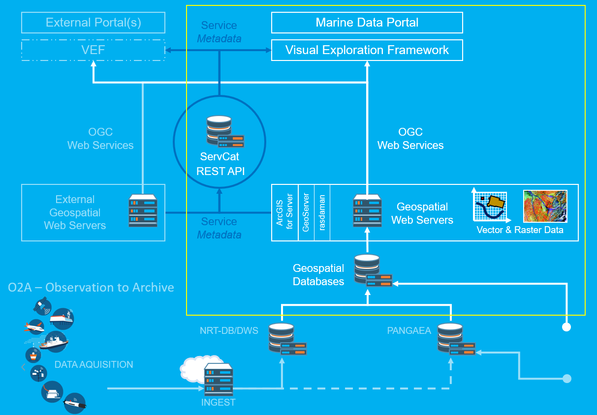
Databases
Several spatial databases are operated in order to harmonise and optimise geodata. This is a necessary step for providing the data in a filterable and standardised way via OGC web services (see next section).
The spatial databases are PostgresSQL instances with spatial extensions. The source code is accessible on Gitlab.
Geospatial Web Servers
Three sorts of geospatial web servers are operated: several ArcGIS for Server instances, a Docker-based cluster of GeoServer instances, and a rasdaman instance. These servers read data from the spatial databases (and file systems) and provide them as OGC web services (OWS) which is a standard way of delivering digital maps and geodata.
Further reading on specific OWS:
- Web Map Service (Wikipedia, OGC standard)
- Web Feature Service (Wikipedia, OGC standard)
- Web Coverage Service (Wikipedia, OGC standard)
O2A Spatial (Software Module)
O2A Spatial is a Python software suite for the automation of two tasks: geodata ingestion and O2A SDI management.
Data ingestion means harvesting OWS metadata into ServCat and harvesting data from different sources, converting it into O2A Data Formats, ingesting it into a spatial database. SDI management takes care or orchestrating geospatial web servers, especially the GeoServer cluster.
The source code is accessible on Gitlab.
Service Catalog
The Service Catalog (ServCat) is a metadata catalog. It holds capabilities information on (mainly) OGC web services in a PostgreSQL database. It can be filled and searched using a REST API (implemented in Java).
Currently a ServCat instance is operated as source for the search functionality in VEF-based viewers.
The source code is accessible on Gitlab.
Visual Exploration Framework
The Visual Exploration Framework (VEF) aims to provide modularized building blocks which can be easily combined and integrated into web-based portals and viewers.
It is built as a JavaScript and CSS library using modern web technologies. The framework builds an additional abstraction layer above common JavaScript frameworks to simplify the composition of visualizations in the context of DAM and MareHub.
Currently it’s used in the Marine Data Portal and its Viewer.
The source code is accessible on Gitlab.
| Info | ||
|---|---|---|
| ||
Overview
Content Tools