| Note | ||
|---|---|---|
| ||
Please note that operations of the Sediment Echo Sounder Atlas Parasound P70 requires experienced scientific staff on board for permanent supervision of data aquisition and storage. The system is not operated by the ship's crew. Announce operations with the Sediment Echo Sounder Atlas Parasound P70 to AWI-Logistics prior to the cruise and clarify the data transfer after the cruise. |
Summary
| Sensorweb integration | ||||
|---|---|---|---|---|
| ||||
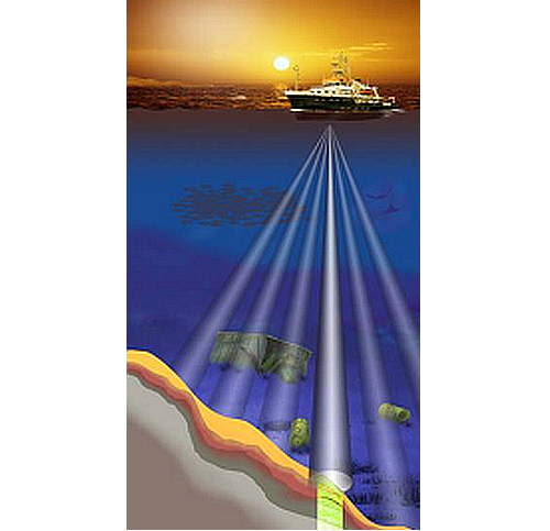
The Sediment Echo Sounder surveys the upper layers of the seafloor via the reflection of acoustic signals. Depending upon the reflectivity of the sediments penetration depths of about 200m can be reached. |
| Sensorweb integration | ||||||||||
|---|---|---|---|---|---|---|---|---|---|---|
| ||||||||||
|
| Sensorweb integration | ||||
|---|---|---|---|---|
| ||||
   |
Transducer Frequency
| Metadata (Metadata Plugin) | ||
|---|---|---|
| ||
Contacts
| Sensorweb integration | |||||||||
|---|---|---|---|---|---|---|---|---|---|
| |||||||||
|
Components
| Metadata (Metadata Plugin) | ||
|---|---|---|
| ||
Position
| Sensorweb integration | ||||||||
|---|---|---|---|---|---|---|---|---|
| ||||||||
|
Data logging, storage and archiving
Logged parameters
| Sensorweb integration | ||||||
|---|---|---|---|---|---|---|
| ||||||
|
Central geographical ship's position and time standard
| Metadata (Metadata Plugin) | ||
|---|---|---|
| ||
Rawdata storage on board
| Metadata (Metadata Plugin) | ||
|---|---|---|
| ||
| Metadata list |
|---|
Dship
| Metadata (Metadata Plugin) | ||
|---|---|---|
| ||
| Metadata list |
|---|
Data archiving on land
| Metadata (Metadata Plugin) | ||
|---|---|---|
| ||
| Metadata list |
|---|
Documentation
| Sensorweb integration | ||||
|---|---|---|---|---|
| ||||