...
| Sensorweb integration | ||||||||||
|---|---|---|---|---|---|---|---|---|---|---|
| ||||||||||
|
| Sensorweb integration | ||||
|---|---|---|---|---|
| ||||
   |
...
| Metadata (Metadata Plugin) | ||||
|---|---|---|---|---|
| High frequency: 19 - 38 kHz; Parametric signal: 0.5 - 6.0 kHz||||
Contacts
| Sensorweb integration | |||||||||
|---|---|---|---|---|---|---|---|---|---|
| |||||||||
|
...
| Metadata (Metadata Plugin) | ||||
|---|---|---|---|---|
| The system consits of the transducer, the electronic unit, two computers with installed data acquisition and processing software ParaStore and the subsidiary display on the bridge.
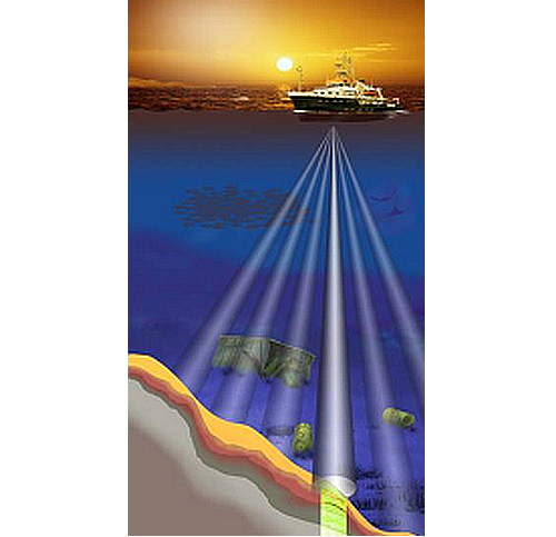
The transducer consists of four segments and is mounted without ice protection window in the box keel. The transducer transmits in the frequency range of 18 - 39 kHz and reaches water depth of 10 to 11000m. Frequency interferences generate "parametric low frequencies" between 0.5 and 6.0 kHz. Penetration depth into the sediment accounts for > 200m (depending on sediment properties) and the resolution is 6.1 cm.||||
Position
| Sensorweb integration | ||||||||
|---|---|---|---|---|---|---|---|---|
| ||||||||
|
Data logging, storage and archiving
...
| Sensorweb integration | ||||||
|---|---|---|---|---|---|---|
| ||||||
|
...
| Metadata (Metadata Plugin) | ||||
|---|---|---|---|---|
| Time synchronising is carried out via NMEA-telegram from the ZDA data set or via ntp between DIP2 and the central ntp-server of the on-board network. DIP2 functions as ntp-server for the computers and residual DIPs of the Parasound System.
The recorded geographical ship's position is the location of the central motion sensor MINS. The lever between transducer and the central motionsensor MINS is considered.||||
Rawdata storage on board
| Metadata (Metadata Plugin) | ||||
|---|---|---|---|---|
| Mass data: The data acquisition and processing software ParaStore creates rawdata on the local drive depending on system configuration. PHF = primary high frequency beam amplitudes, SLF = secondary low frequency beam amplitudes, SHF = secondary high frequency beam amplitudes. Synchonising of the local data directory to mass storage has to be carried out manually. A reduced set of uncorrected measurement data is stored to the DShip system.||||
| Metadata list |
|---|
|| root directory | R:\data01\parasound\ ||
|| directory name | CruiseNo\XXX_ASD_YYYYMMDD \\ CruiseNo\XXX_PS3_YYYYMMDD \\ CruiseNo\XXX_SGY_YYYYMMDD \\ CruiseNo\screenshots \\ CruiseNo\PSAUX \\ CruiseNo\DSHIP \\ with \\ XXX = PHF, SLF or SHF \\ YYYY = year \\ MM = month \\ DD = day \\ e.g. \\ ANT25-3\PHF_ASD_20090113\ \\ ... ||
|| file name | PS3XXX\_YYYY-MM-DDThhmmssZ\_<identNo>.asd.acf \\ PS3XXX\_YYYY-MM-DDThhmmssZ\_<identNo>.asd.acf.idx \\ XXXYYMMDDhhmm.ps3 \\ XXXYYMMDDhhmm.sgy \\ YYYYMMDD-YYYYMMDD\YYYYMMDD_hhmm*.bmp \\ ??? \\ NAV_YYYYMMDD-YYYYMMDD.txt \\ with \\ XXX = PHF, SLF or SHF \\ YYYY = year \\ MM = month \\ DD = day \\ hh = hour \\ mm = minute \\ ss = second \\ <identNo> = 8-digit running number \\ e.g. \\ PS3PHF\_2009-01-13T112415Z\_00000005.asd.acf \\ ...||
|| Data volume (MB per day) ca | 10000 ||
|| Number of files per day ca | 1000 || |
Dship
| Metadata (Metadata Plugin) | ||||
|---|---|---|---|---|
| Reduced set of uncorrected measurement data.||||
| Metadata list |
|---|
|| Device name | parasound ||
|| Parameters | depth \[m\] || |
Data archiving on land
| Metadata (Metadata Plugin) | ||
|---|---|---|
| ||
After the cruise, the operator transfers the measurement data along with required meta data to AWI after consultaion with the data scientist and AWI Logistics. Then, the data (including meta data) can be extracted from https://www.pangaea.de/ (for authorized users only). The reduced, unevaluated DShip data set can be extracted from https://dship.awi.de/. | ||
| Metadata list |
|---|
Documentation
| Sensorweb integration | ||||
|---|---|---|---|---|
| ||||
...