...
| Sensorweb integration |
|---|
| urn | vessel:polarstern:gravimeter |
|---|
| contenttype | Summary |
|---|
|
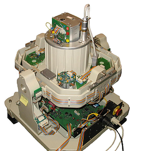
A gravimeter is used to measure accelerations due to the gravitational field of the earth. The gravimeter on board of Polarstern is situated on a gyro-stabilized platform to compensate for the ships ship's movement. It is a spring and mass system with magnetic compensation, the length extension of the spring being proportional to the gravitationgravitational force. |
| Sensorweb integration |
|---|
| urn | vessel:polarstern:gravimeter |
|---|
| contenttype | Metadata |
|---|
|
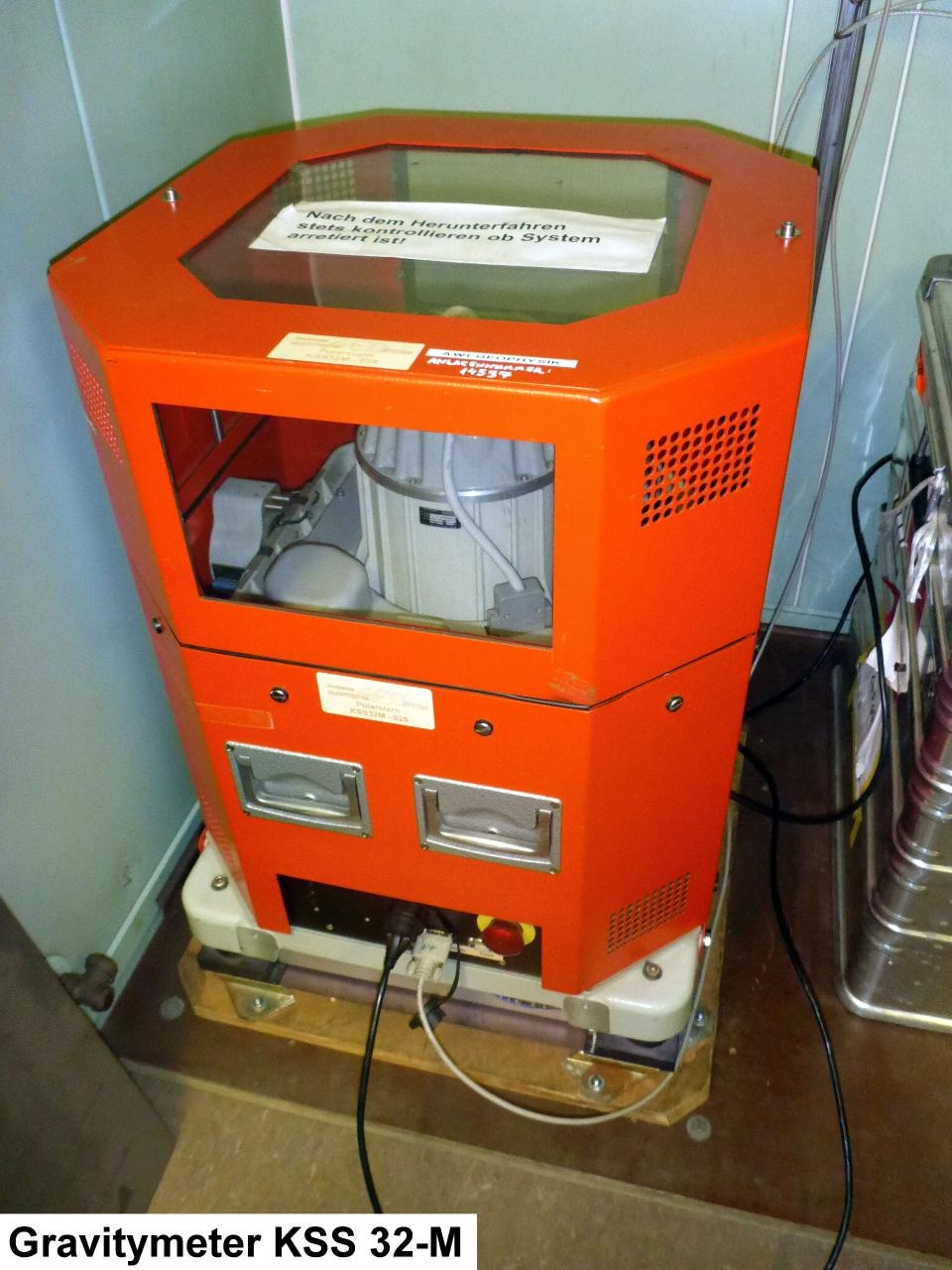
| Manufacturer | Bodensee Gravitymeter Geosystem GmbH (BGGS) |
|---|
| Model | KSS 32 M |
|---|
| Serial No. | n/a |
|---|
| Type | gravimeter |
|---|
| SENSORREGISTRY-Link | ↪ REGISTRY (1406) |
|---|
|
| Sensorweb integration |
|---|
| urn | vessel:polarstern:gravimeter |
|---|
| contenttype | Images |
|---|
|
|
...
| Sensorweb integration |
|---|
| urn | vessel:polarstern:gravimeter |
|---|
| contenttype | Contacts |
|---|
|
| Name | Institution | Role |
|---|
| Graeme EaglesThorsten Eggers | Alfred - Wegener Institute of , Helmholtz Centre for Polar and Marine Research | Principal Investigator, Data Scientist | Thorsten EggersEngineer In Charge | | Alfred - Wegener - Institute for Polar and Marine ResearchEngineer In Charge | Alfred Wegener Institute, Helmholtz Centre for Polar and Marine Research | Owner | | Graeme Eagles | Alfred Wegener Institute, Helmholz Helmholtz Centre for Polar and Marine Research | OwnerPrincipal Investigator, Data Scientist |
|
Components
| Metadata (Metadata Plugin) |
|---|
|
The Marine Gravitymeter System consits of the Gravitymeter KSS 32-M and the operator-laptop in the Gravitymeter Room on board. The Gravitymeter control system and data acquisition software BGGS DACQS is installed on the laptop.
|
|
Position
| Sensorweb integration |
|---|
| urn | vessel:polarstern:gravimeter |
|---|
| contenttype | LocalFrame |
|---|
|
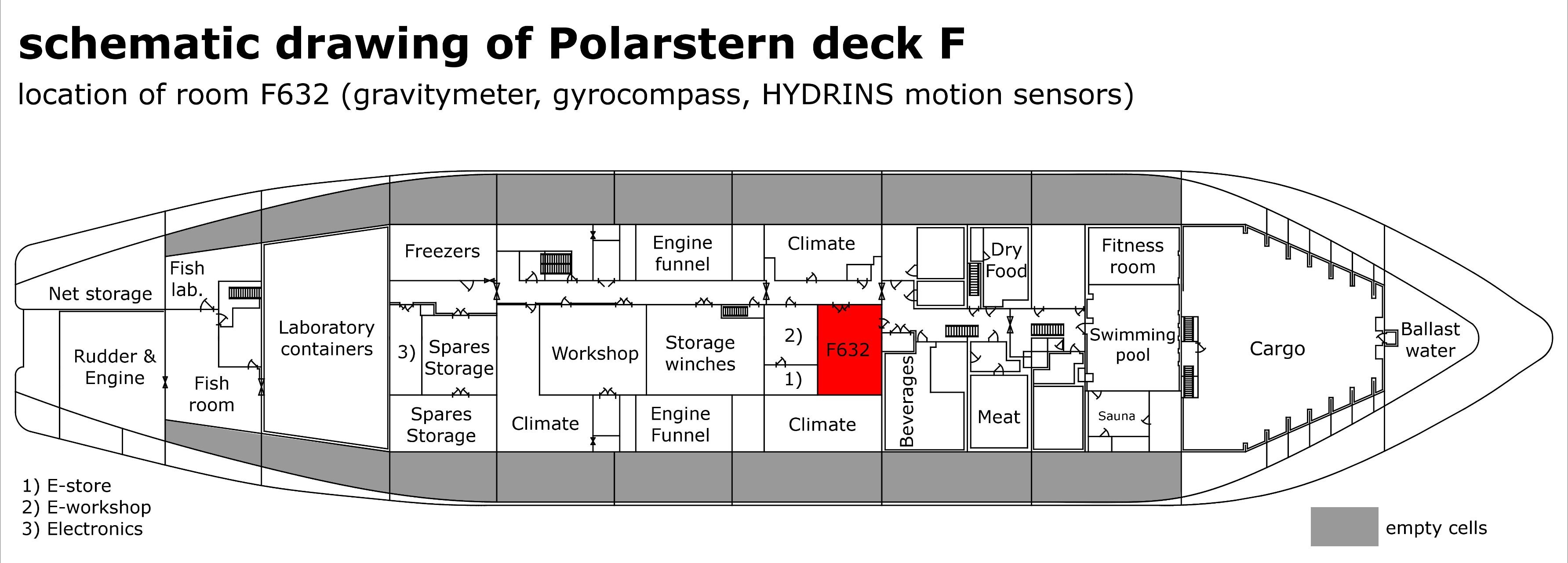
| Info | xyz-position from Alignment Survey Report RV Polarstern (June 2016), located in F632 | | X | 56.99 m
(X-0 is at the center of der rudder (ref. design drawing of the vessel), positive X-axis is forward and along vessel centerline) | | Y | 0.147 m
(Y-0 at centerline, positive Y-axis is portside) | | Z | 11.81 m
(Z-0 is set to the lowest point of the keel, positive Z-axis is upwards) |
|
...
| Sensorweb integration |
|---|
| urn | vessel:polarstern:gravimeter |
|---|
| contenttype | Parameters |
|---|
|
| Parameter | Sensor O2ARegistry Output Type | Unit |
|---|
| acceleration | acceleration | m/s^2s2 | | gravityGravity | gravity | mGal |
|
Central geographical ship's position and time standard
| Metadata (Metadata Plugin) |
|---|
| Time stamp from DShip NMEA telegram.
A gyro-stabilized platform accounts for compensation of the ship's movements. Navigation data from DShip NMEA telegram. |
|
Rawdata storage on board
| Metadata (Metadata Plugin) |
|---|
|
Data storage in DShip system. Rawdata backup to operator-laptop is possible.
|
|
Dship
| Metadata (Metadata Plugin) |
|---|
| Uncorrected measurement data. |
|
| Metadata list |
|---|
|| Device name | gravimeter ||
|| Parameters | GRAVIMETER.PBGGGD.1.datafield3; GRAVIMETER.PBGGGD.1.datafield4; GRAVIMETER.PBGGGD.2.datafield1; GRAVIMETER.PBGGGD.2.datafield2; GRAVIMETER.PBGGGD.2.datafield3; GRAVIMETER.PBGGGD.2.datafield4 || |
|---|
|
Data archiving on land
| Metadata (Metadata Plugin) |
|---|
| After the cruise the DShip data set can be extracted from https://dship.awi.de/. |
|
| Metadata list |
|---|
|| File format(s) | stored in DShip system ||
|| Calibration certificates | stored in Gravitimeter Room F632 || |
|---|
|
Documentation
The manuals are located in the Gravitymeter Room on board.
...