...
| Sensorweb integration |
|---|
| urn | vessel:heincke:ememlog_log1407-0260 |
|---|
| contenttype | Summary |
|---|
|
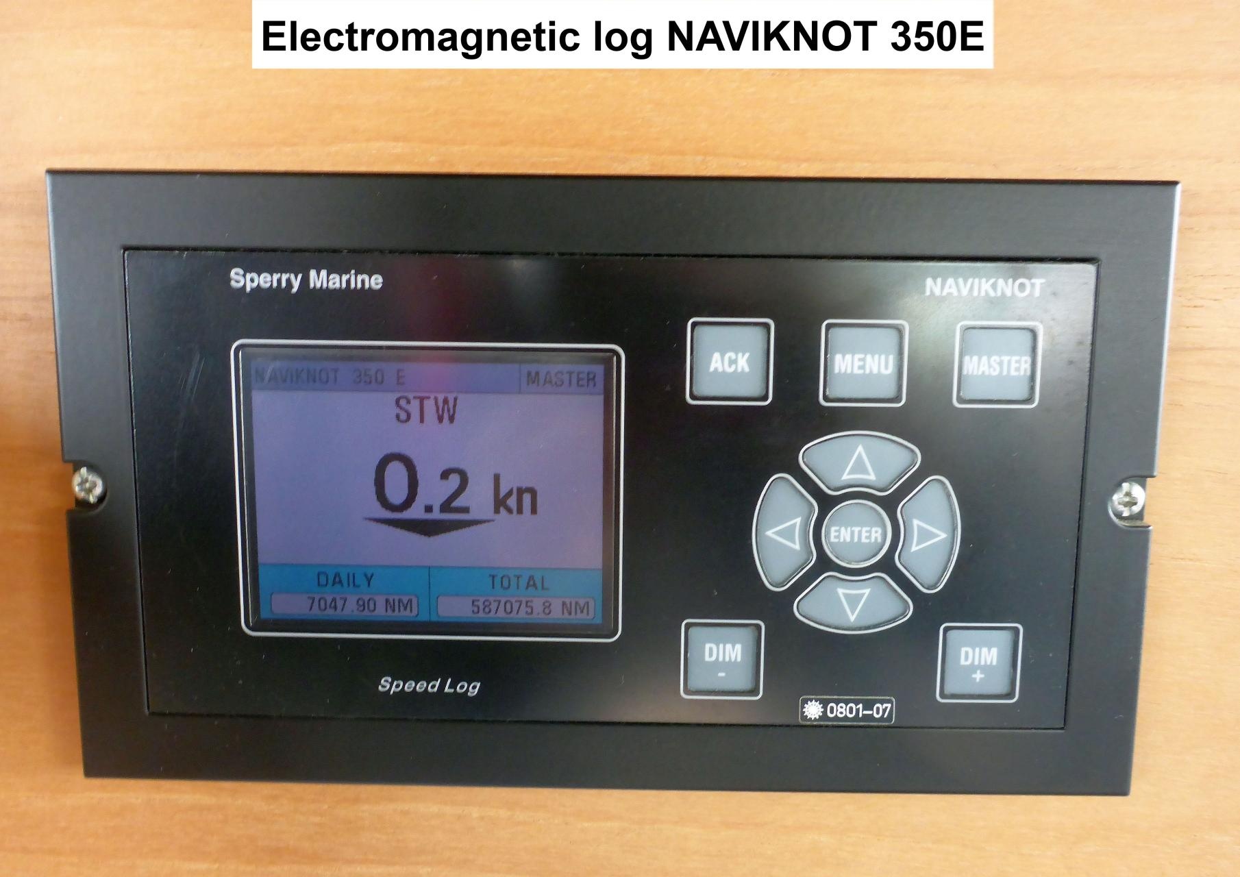
The electromagnetic log measures the speed of the vessel through water. Display type: NAVIKNOT 350E |
| Sensorweb integration |
|---|
| urn | vessel:heincke:ememlog_log1407-0260 |
|---|
| contenttype | Metadata |
|---|
|
Sperry MarineNAVIKNOT 350E| Sperry Marine, Type 2829-2100-00, REV: C, STO No 073266 | | Serial No. |
|---|
n/a |
| Sensorweb integration |
|---|
| urn | vessel:heincke:ememlog_log1407-0260 |
|---|
| contenttype | Images |
|---|
|
|
Contacts
| Sensorweb integration |
|---|
| urn | vessel:heincke:ememlog_log1407-0260 |
|---|
| contenttype | Contacts |
|---|
|
| Name | Institution | Role |
|---|
| Reederei Briese |
Reederei | Briese Schiffahrts GmbH & Co. KG | Engineer In Charge |
|
Components
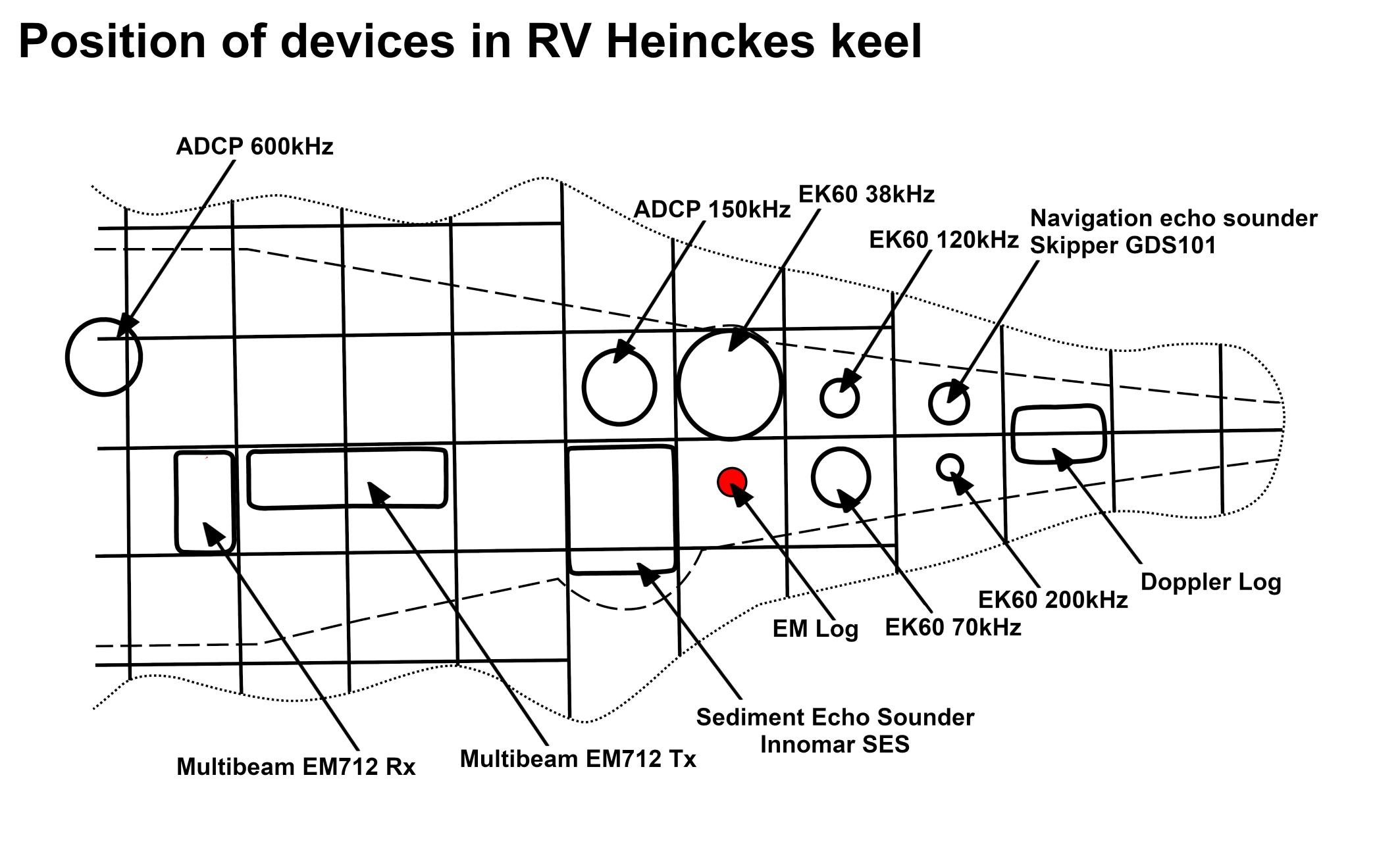
The system consists of the EM Log transducer located in the keel and an operational unit on the bridge deck.
| Sensorweb integration |
|---|
| urn | vessel:heincke:ememlog_log1407-0260 |
|---|
| contenttype | Subdevices |
|---|
|
No subdevices found for this sensoravailable. |
Position
| Sensorweb integration |
|---|
| urn | vessel:heincke:ememlog_log1407-0260 |
|---|
| contenttype | LocalFrame |
|---|
|
Origin Description:| Info | xyz-position of transducer from Alignment Survey Report RV Heincke (January 2016). Electronics and operation on bridge deck. | | X |
: | 45.564 m
(Positive X axis is forward and along the centerline of the vessel with X0 at the Stern point of the vessel.) | | Y |
: | -0.25 m
(Positive Y axis is portside of centerline with Y0 at centerline at the Very stern point of the vessel.) | | Z |
: | -0.087 m
(Positive Z axis is upwards of basis. Z0 is set to the hydrophone on midship.) |
|
Data logging, storage and archiving
Logged parameters
| Sensorweb integration |
|---|
| urn | vessel:heincke:ememlog_log1407-0260 |
|---|
| contenttype | Parameters |
|---|
|
Sensor | O2ARegistry Output Type | Unit |
|---|
| longitudinal water speed | speed |
knots| knot | | longitudinal ground speed | speed |
knots |
Central geographical ship's position and time standard
| Metadata (Metadata Plugin) |
|---|
| Time synchronization and geographical positioning is done by DShip receiving the data for logging. |
|
Rawdata storage on board
| Metadata (Metadata Plugin) |
|---|
|
Data storage in DShip system.
|
|
DShip
| Metadata (Metadata Plugin) |
|---|
| Uncorrected measurement data. |
|
| Metadata list |
|---|
|| Device name | EM Log ||
|| Parameters| Longitudinal ground speed \[kn\]; Longitudinal water speed \[kn\] || |
|
Data archiving on land
...
| Metadata (Metadata Plugin) |
|---|
|
|
Documentation
| Sensorweb integration |
|---|
| urn | vessel:heincke:ememlog_log1407-0260 |
|---|
| contenttype | Resources |
|---|
|
|