| Note |
|---|
|
The Navigation Echo Sounder is operated by ship's command only. |
Summary
| sensorweb-integration |
|---|
| urn | vessel:polarstern:navigation_sounder |
|---|
| contenttype | Summary |
|---|
|
The navigation echo sounder delivers depth information in order to avoid grounding and ensure save ship navigation. |
| sensorweb-integration |
|---|
| urn | vessel:polarstern:navigation_sounder |
|---|
| contenttype | Metadata |
|---|
|
| Manufacturer | Wärtsilä ELAC Nautik GmbH |
|---|
| Model | LAZ 5100 |
|---|
| Serial No. | n/a |
|---|
| Type | not assigned |
|---|
| REGISTRY-Link | ↪ REGISTRY (1403) |
|---|
|
...
html-Links Spaces:
Summary
Description
Contacts
Parameters
Resources
Events
Subdevices
Images
Position
----------------------------------------------------------------------
| integration |
|---|
| urn | vessel:polarstern:navigation_sounder |
|---|
| contenttype | Images |
|---|
|
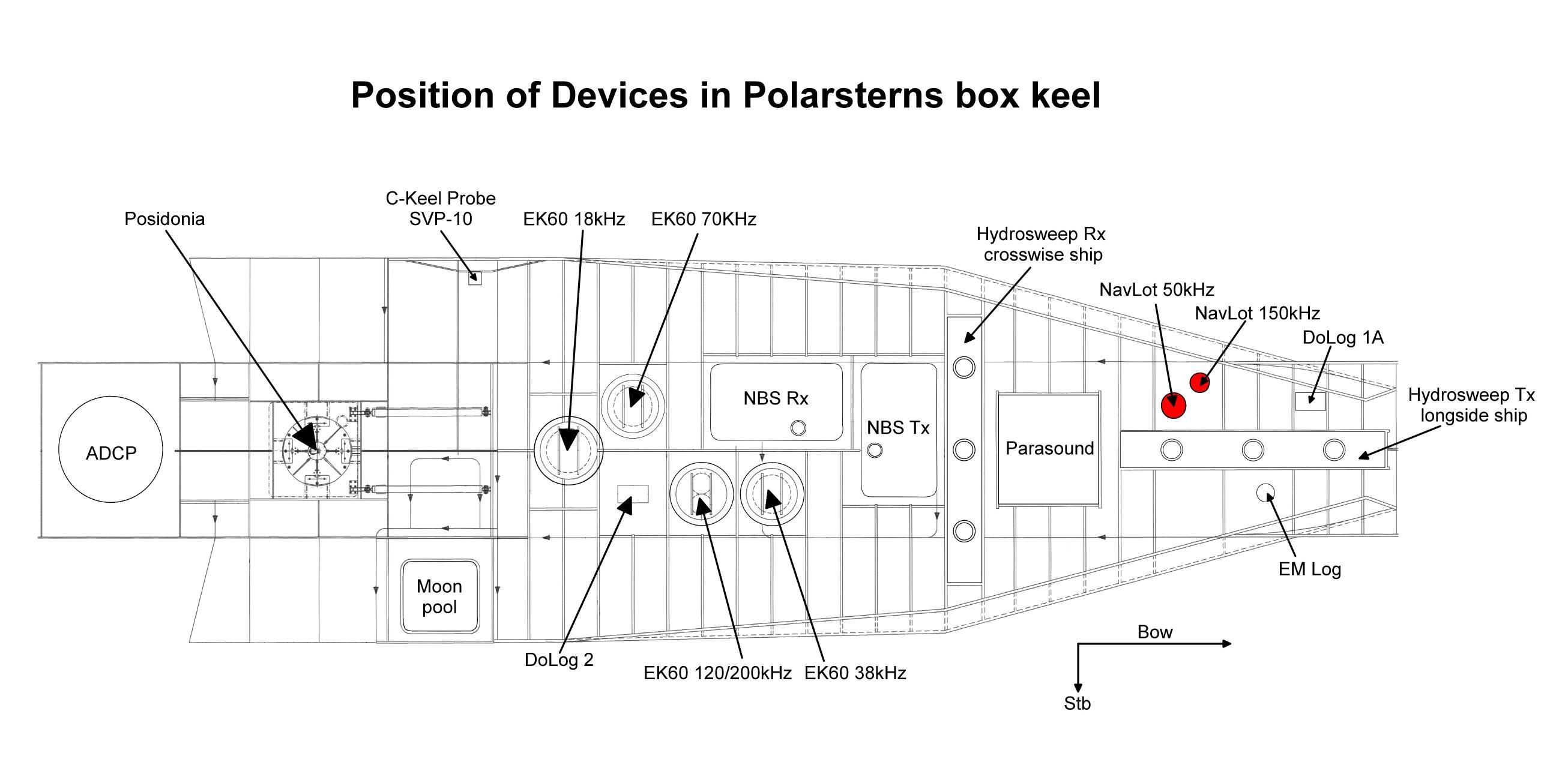 Image Added Image Added 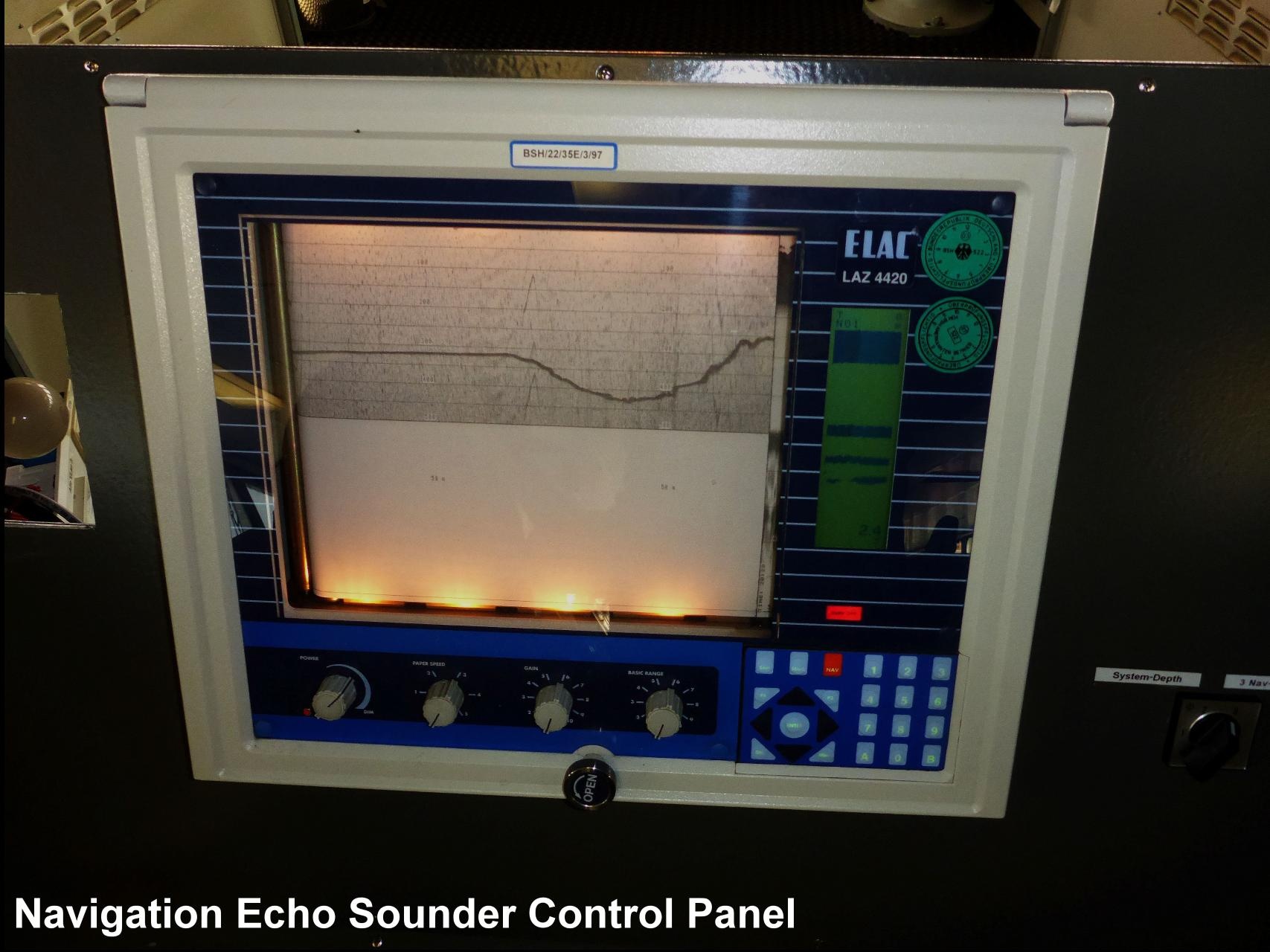 Image Added Image Added |
Transducer Frequency:
| Metadata (Metadata Plugin) |
|---|
|
|
Contacts
| Sensorweb integration |
|---|
| urn | vessel:polarstern:navigation_sounder |
|---|
| contenttype | Contacts |
|---|
|
| Name | Institution | Role |
|---|
| Reederei Laeisz | F. Laeisz | Engineer In Charge |
|
Components
| Metadata (Metadata Plugin) |
|---|
|
|
Subdevices
| Sensorweb integration |
|---|
| urn | vessel:polarstern:navigation_sounder |
|---|
| contenttype | Subdevices |
|---|
|
|
Position
| Sensorweb integration |
|---|
| urn | vessel:polarstern:navigation_sounder |
|---|
| contenttype | LocalFrame |
|---|
|
| Info | xyz-position calculated from Alignment Survey Report RV Polarstern (2016), transducers located in box keel, electronics located on bridge | | X | 78.095 m
(X-0 is at the center of der rudder (ref. design drawing of the vessel), positive X-axis is forward and along vessel centerline ) | | Y | 0.627 m
(Y-0 at centerline, positive Y-axis is portside ) | | Z | 0.014 m
(Z-0 is set to the lowest point of the keel, positive Z-axis is upwards) |
|
Data logging, storage and archiving
Logged parameters
| Sensorweb integration |
|---|
| urn | vessel:polarstern:navigation_sounder |
|---|
| contenttype | Parameters |
|---|
|
| Parameter | O2ARegistry Output Type | Unit |
|---|
| depth | depth | m |
|
Central geographical ship's position and time standard
| Metadata (Metadata Plugin) |
|---|
|
|
Rawdata storage on board
| Metadata (Metadata Plugin) |
|---|
|
|
Dship
| Metadata (Metadata Plugin) |
|---|
|
|
Data archiving on land
| Metadata (Metadata Plugin) |
|---|
|
|
...