| Note |
|---|
|
The Doppler Log (DO Log) is part of nautical equipment. The operation belongs to the bridge only. |
Summary
| Sensorweb integration |
|---|
| urn | vessel:heincke:do_log |
|---|
| contenttype | Summary |
|---|
|
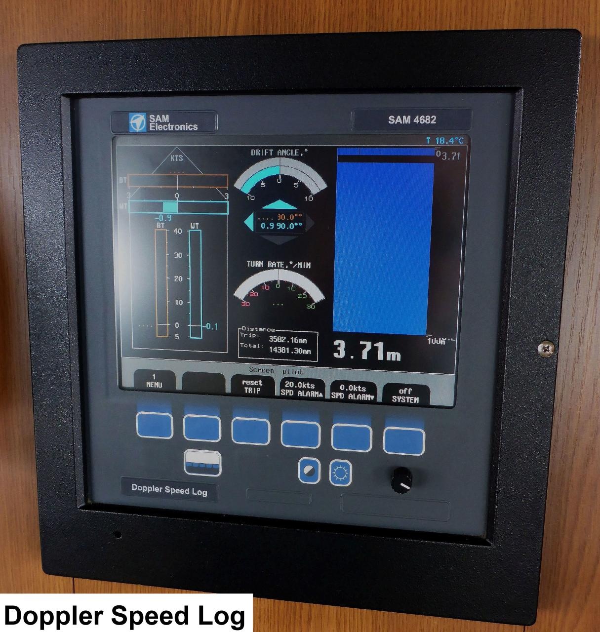
The Doppler log measures speed through water by using the Doppler effect of sound signal reflected from the seafloor or from suspended matter in the water column. Wärtsilä SAM 4682 transducer consists of a total of 3 hydro-acoustic elements of 270 kHz. |
| Sensorweb integration |
|---|
| urn | vessel:heincke:do_log |
|---|
| contenttype | Metadata |
|---|
|
| Manufacturer | Wärtsila SAM Electronics |
|---|
| Model | SAM4682 |
|---|
| Serial No. | n/a |
|---|
| Type | speed log |
|---|
|
| Sensorweb integration |
|---|
| urn | vessel:heincke:do_log |
|---|
| contenttype | Images |
|---|
|
|
Transducer Frequency:
270kHz
| Sensorweb integration |
|---|
| urn | vessel:heincke:do_log |
|---|
| contenttype | Contacts |
|---|
|
| Name | Institution | Role |
|---|
| Reederei Briese | Reederei Briese | Engineer In Charge |
|
Components
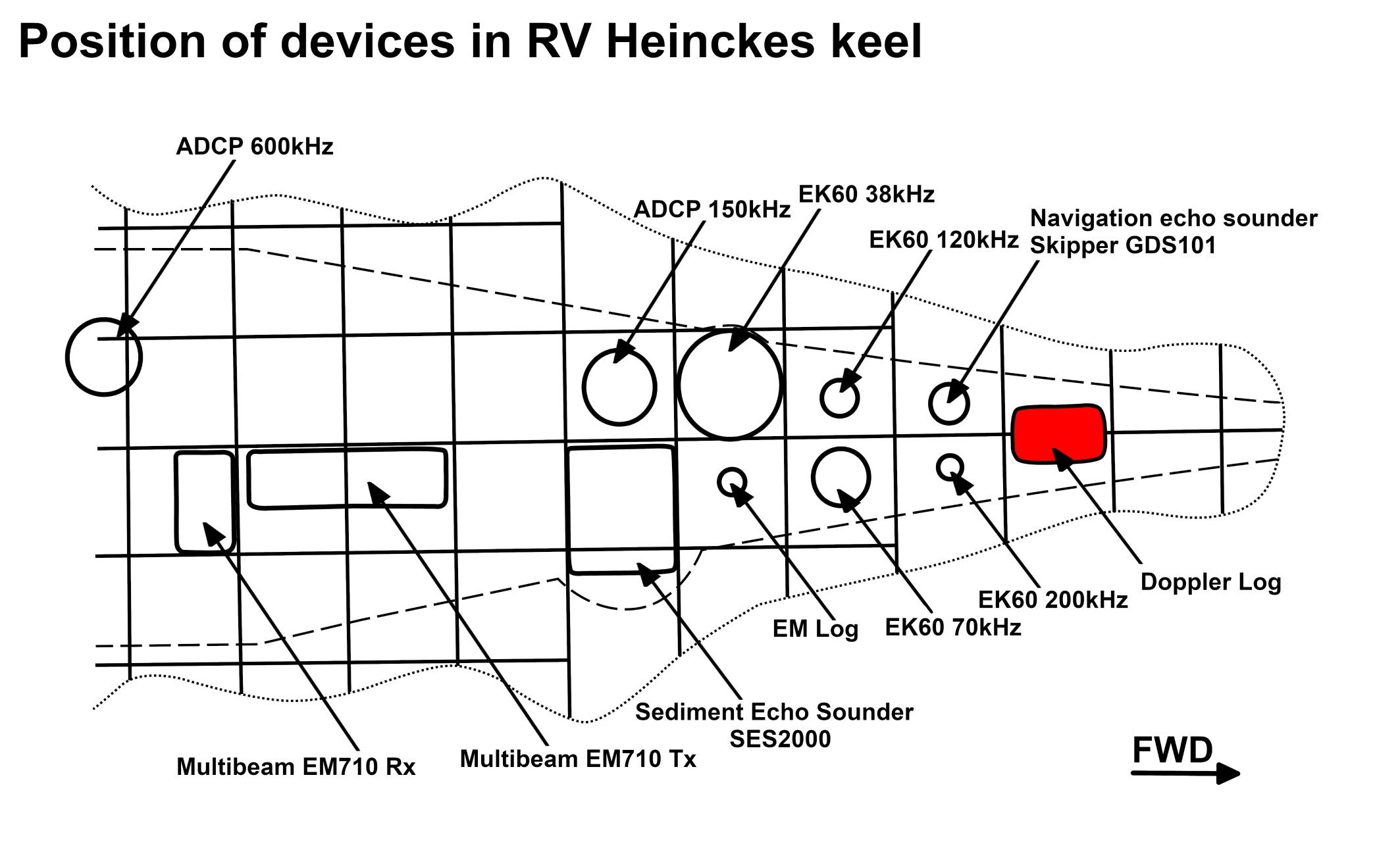
The system consists of a transducer with 3 hydro-acoustic elements installed in the ship's keel. It is operated from the bridge.
| Sensorweb integration |
|---|
| urn | vessel:heincke:do_log |
|---|
| contenttype | Subdevices |
|---|
|
No subdevices found for this sensor. |
Position
| Sensorweb integration |
|---|
| urn | vessel:heincke:do_log |
|---|
| contenttype | LocalFrame |
|---|
|
| Origin Description: | xyz-position of transducer from Alignment Survey Report RV Heincke (January 2016). Electronics and operation on bridge deck. | | X: | 47.221 m
(Positive X axis is forward and along the centerline of the vessel with X0 at the Stern point of the vessel. ) | | Y: | 0.017 m
( Positive Y axis is portside of centerline with Y0 at centerline at the Very stern point of the vessel. ) | | Z: | 0.074 m
(Positive Z axis is upwards of basis. Z0 is set to the hydrophone on midship.) |
|
Data logging, storage and archiving
Logged parameters
| Sensorweb integration |
|---|
| urn | vessel:heincke:do_log |
|---|
| contenttype | Parameters |
|---|
|
| Parameter | Sensor Output Type | Unit |
|---|
| longitudinal ground speed | speed | knots | | longitudinal water speed | speed | knots | | transverse water speed | speed | knots | | transverse ground speed | speed | knots |
|
Central geographical ship's position and time standard
| Metadata (Metadata Plugin) |
|---|
|
Time synchronization and geographical positioning is done by DShip receiving the data for logging. |
Rawdata storage on board
| Metadata (Metadata Plugin) |
|---|
|
Data storage in DShip system.
|
DShip
| Metadata (Metadata Plugin) |
|---|
|
Uncorrected measurement data. |
| Metadata list |
|---|
|| Device name | Dolog ||
|| Parameters| Dolog.VDVBW.Sentence; Longitudinal ground speed \[kn\]; Longitudinal water speed \[kn\]; Transverse ground speed \[kn\]; Transverse water speed \[kn\] || |
Data archiving on land
| Metadata (Metadata Plugin) |
|---|
|
After the cruise the DShip data set can be extracted from https://dms.awi.de.
|
Documentation
| Sensorweb integration |
|---|
| urn | vessel:heincke:do_log |
|---|
| contenttype | Resources |
|---|
|
|